IMAGES TAKEN NEAR TO
Botolphs Road, STEYNING, BN44 3WT
Introduction
This page details the photographs taken nearby to Botolphs Road, BN44 3WT by members of the Geograph project.
The Geograph project started in 2005 with the aim of publishing, organising and preserving representative images for every square kilometre of Great Britain, Ireland and the Isle of Man.

There are currently over 7.5m images from over14,400 individuals and you can help contribute to the project by visiting https://www.geograph.org.uk
Image Map
Images are licensed for reuse under creativecommons.org/licenses/by-sa/2.0
Notes
- Clicking on the map will re-center to the selected point.
- The higher the marker number, the further away the image location is from the centre of the postcode.
Image Listing (30 Images Found)
Images are licensed for reuse under creativecommons.org/licenses/by-sa/2.0
Image
Details
Distance
1
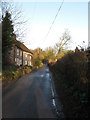
Cottages, Botolphs Road
Hob Holly is the nearest whilst Bank Cottage is the furthest. The lane is the minor road that links Steyning with the Sussex Pad Inn on the A27.
Image: © Simon Carey
Taken: 8 Mar 2009
0.01 miles
2
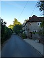
Bank Cottage/High Hobby, Botolphs Road, Annington
Semi-detached cottages dating from the early 19th century. High Hobby is the name of the one to the east.
Image: © Simon Carey
Taken: 30 Jul 2020
0.01 miles
3
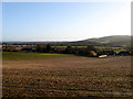
Annington Road, Botolphs
A thriving village in the Middle Ages, with navigable river connection to the sea. Now a small village of mainly large houses strung out along a single road.
Image: © Tim Heaton
Taken: 10 May 2011
0.01 miles
4
House on the south side of Annington Road
This was taken from the footpath a couple of hundred metres to the south-west of the house.
Image: © Ian Hawfinch
Taken: 23 Mar 2020
0.01 miles
5

Annington House, Botolphs Road, Annington
Built in the early 19th century.
Image: © Simon Carey
Taken: 30 Jul 2020
0.06 miles
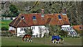
7
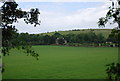
Annington Farm
Viewed from the bridleway that links the South Downs Way with Coombes Road. Upper Beeding and Truleigh Hill are on the far side of the valley.
Image: © Simon Carey
Taken: 8 Mar 2009
0.08 miles
8
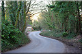
Annington Road
The lane along the west side of the Adur valley doesn't lack in bends. Here called Annington Road, further down it becomes Coombes Road.
Image: © Robin Webster
Taken: 4 Mar 2010
0.08 miles
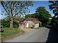
9
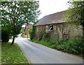
Annington: old farm buildings
A good number of farm outbuildings at Annington have been spruced up and converted - but not the barn nearest the camera here, which seems to have stood unused for some years. It can be seen (from the far end) in Simon Carey's contribution Image (which also provides a thoughtful commentary on the history of this little area).
Image: © Stefan Czapski
Taken: 3 Aug 2019
0.10 miles
10
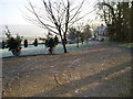
Driveway to Annington House, Annington Road
Looking over the Adur Valley on a cold icy morning.
Image: © Peter Holmes
Taken: 3 Jan 2009
0.10 miles