IMAGES TAKEN NEAR TO
Church House Close, BRIGHTON, BN42 4WQ
Introduction
This page details the photographs taken nearby to Church House Close, BN42 4WQ by members of the Geograph project.
The Geograph project started in 2005 with the aim of publishing, organising and preserving representative images for every square kilometre of Great Britain, Ireland and the Isle of Man.

There are currently over 7.5m images from over14,400 individuals and you can help contribute to the project by visiting https://www.geograph.org.uk
Image Map
Images are licensed for reuse under creativecommons.org/licenses/by-sa/2.0
Notes
- Clicking on the map will re-center to the selected point.
- The higher the marker number, the further away the image location is from the centre of the postcode.
Image Listing (12 Images Found)
Images are licensed for reuse under creativecommons.org/licenses/by-sa/2.0
Image
Details
Distance
1
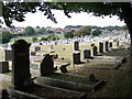
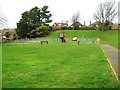
Cemetery, Southwick Hill
Beyond this post war cemetery there are paddocks and all is now surrounded by housing in this square.
Image: © Bob Embleton
Taken: 9 Sep 2005
0.10 miles
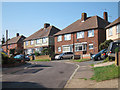
2
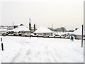
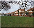
Bungalows, Overhill
Viewed from the junction with Holmbush Way with Easthill cemetery visible beyond. The man on the right has just discovered that 8-10 inches of snow obscures the step between the kerb and the road. Much of Southwick north of Old Shoreham was developed in the immediate postwar years.
Image: © Simon Carey
Taken: 2 Dec 2010
0.13 miles
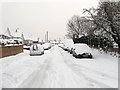
3
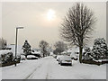
Overhill
Residential road running between Windmill Parade and Downsway that was developed in the immediate postwar years. Shoreham Power Station can be seen in the distance whilst the sun makes an effort to break through a gap in the cloud.
Image: © Simon Carey
Taken: 2 Dec 2010
0.16 miles
7
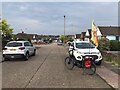
Mile Oak Road
near the junction with the Old Shoreham Road
Image: © Paul Gillett
Taken: 24 Jan 2010
0.23 miles
8
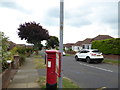
Pillar box at bus stop on Overhill
This is in West Sussex.
Image: © Shazz
Taken: 29 Aug 2016
0.23 miles
10
Downland Avenue
Residential road that runs parallel with Old Shoreham Road, the A270, between Upper Kingston Lane and Overhill. The section in view lies between the latter and The Drive.
Image: © Simon Carey
Taken: 2 Dec 2010
0.23 miles