IMAGES TAKEN NEAR TO
Old Mill Close, BRIGHTON, BN41 1PQ
Introduction
This page details the photographs taken nearby to Old Mill Close, BN41 1PQ by members of the Geograph project.
The Geograph project started in 2005 with the aim of publishing, organising and preserving representative images for every square kilometre of Great Britain, Ireland and the Isle of Man.

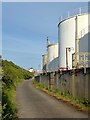
There are currently over 7.5m images from over14,400 individuals and you can help contribute to the project by visiting https://www.geograph.org.uk
Image Map
Images are licensed for reuse under creativecommons.org/licenses/by-sa/2.0
Notes
- Clicking on the map will re-center to the selected point.
- The higher the marker number, the further away the image location is from the centre of the postcode.
Image Listing (78 Images Found)
Images are licensed for reuse under creativecommons.org/licenses/by-sa/2.0
Image
Details
Distance
1
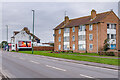
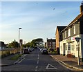
Fishersgate Terrace
Housing and a kebab house on Fishersgate Terrace. The building on the right is part of the Old Mill Close estate.
Image: © Ian Capper
Taken: 21 Jan 2022
0.03 miles
2
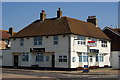
Albion Inn, Fishersgate, Sussex
Located on the junction of Fishersgate Terrace and West Road.
As at June 2011, the 'Albion' is under new ownership/management, has been re-furbished, and is open for meals seven days per week.
Image: © Peter Trimming
Taken: 17 Apr 2010
0.03 miles
3
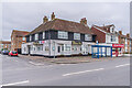
Albion Inn
19th Century pub on the corner of West Road and Fishersgate Terrace.
Image: © Ian Capper
Taken: 21 Jan 2022
0.05 miles
4
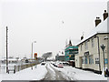
West Road, Fishersgate
Developed during the mid 19th century as Shoreham Harbour grew and associated industries sprang up on the north bank. The Albion Inn is on the right and was named after an old oyster shop that had been built from the wrecked hulk of a ship called the Albion. A small recreation ground is on the left.
Image: © Simon Carey
Taken: 2 Dec 2010
0.05 miles
5
Shoreham Oil Terminal
Viewed from the track which is a continuation of Waterside Road and allows access to North Canal Bank.
Image: © Simon Carey
Taken: 17 May 2020
0.06 miles
6
West Road, Fishersgate
Linking Fishersgate Terrace, the A259, to Gardner Road and originally built in the 1860s. The original terraced housing on the eastern site has long been removed with just the Albion Inn surviving.
Image: © Simon Carey
Taken: 17 May 2020
0.06 miles
7
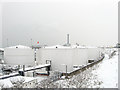
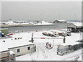
Texaco Oil Terminal
Small oil terminal on the northern side of the canal whose colour blends in to the surroundings after 8-10 inches of snow fell overnight. Note the small low lying cliffs that separate the A259 from the industries below. Beyond is the chimney of Shoreham Power Station.
Image: © Simon Carey
Taken: 2 Dec 2010
0.06 miles
8
Shoreham Oil Terminal
Oil terminal on Shoreham Harbour, seen from Fishersgate Terrace.
Image: © Ian Capper
Taken: 21 Jan 2022
0.06 miles
9
Texaco Wharf
Home to a small Texaco oil terminal. Beyond is the Arc Terminal home to Solent Aggregates.
Image: © Simon Carey
Taken: 2 Dec 2010
0.07 miles
10
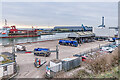
Shoreham Oil Terminal
Oil terminal on Shoreham Harbour, seen from Fishersgate Terrace. The ship on the left is the City of Chichester, a hopper dredger built in 1997.
Image: © Ian Capper
Taken: 21 Jan 2022
0.07 miles