IMAGES TAKEN NEAR TO
Meads Avenue, HOVE, BN3 8EE
Introduction
This page details the photographs taken nearby to Meads Avenue, BN3 8EE by members of the Geograph project.
The Geograph project started in 2005 with the aim of publishing, organising and preserving representative images for every square kilometre of Great Britain, Ireland and the Isle of Man.

There are currently over 7.5m images from over14,400 individuals and you can help contribute to the project by visiting https://www.geograph.org.uk
Image Map
Images are licensed for reuse under creativecommons.org/licenses/by-sa/2.0
Notes
- Clicking on the map will re-center to the selected point.
- The higher the marker number, the further away the image location is from the centre of the postcode.
Image Listing (30 Images Found)
Images are licensed for reuse under creativecommons.org/licenses/by-sa/2.0
Image
Details
Distance
1
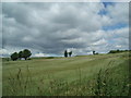
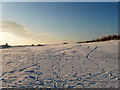
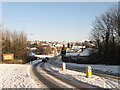
Downland south of the A27
Heading north from Sainsbury's, Hove
Image: © Paul Gillett
Taken: 20 Jun 2009
0.08 miles
2
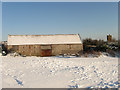
Benfield Barn
A late 18th century flint barn that is the only survivor from Benfield Manor Farm which operated from here from the late 16th century to 1871 when the farmhouse was demolished and replaced by a row of agricultural labourer's cottages. They in turn have nearly gone, the lone chimney on the right along with the concealed foundations being the only thing left of them. The barn is currently the clubhouse for the Benfield Valley Golf Course.
Image: © Simon Carey
Taken: 7 Jan 2010
0.08 miles
3
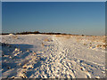
Footpath, Benfield Valley Golf Course
Geographically this is actually the southern part of Benfield Hill which has been split from the rest by the A27 which lurks in the cutting beyond the bushes in the distance. The footpath begins at Hangleton Lane, crosses the by-pass then Benfield Hill before heading north to join the Monarch's Way.
Image: © Simon Carey
Taken: 7 Jan 2010
0.09 miles
4
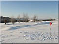
Benfield Valley Golf Course
This is the ninth hole of nine on a course that was laid out in the early 1990s using some of the older abandoned fairways of West Hove Golf Course. The latter relocated to land north of the A27 when that road was constructed having been split in two by it and lost some more land to the Hangleton Link Road. The view takes in Foredown Tower on the left and Southwick Hill in the distance on the right.
Image: © Simon Carey
Taken: 7 Jan 2010
0.11 miles
5
Short Third, Benfield Valley Golf Course
Running parallel to the A27 which lies in a cutting below the bushes to the right. The course was opened in the early 1990s using some of the fairways vacated by the West Hove Golf Club which relocated to a new course north of the newly opened by-pass which had been built through part of that course along with a link road. Benfield Valley Golf Course has nine holes, five south of A27 and four north of it. Valley is a bit of a misnomer here as this hole is on the southern part of Benfield Hill which was also split in two by the by-pass.
Image: © Simon Carey
Taken: 7 Jan 2010
0.11 miles
6
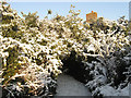
Underneath the Arches
This path requires some bending of the knees to duck under the low lying foliage. The chimney is the only remaining structure left standing of a row of late Victorian agricultural labourer's cottages that were built on the site of Benfield Manor Farm that was demolished in 1871.
Image: © Simon Carey
Taken: 7 Jan 2010
0.13 miles
7
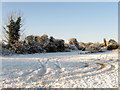
Car Park, Benfield Valley Golf Course
The 9 hole golf course is situated in the northern part of Benfield Valley using some of the fairways vacated by West Hove Golf Course when it relocated north of the A27. The chimney in view is one of the few structural remains of a row of late 19th century agricultural labourer's cottages that were built on the site of Benfield Manor Farm which was demolished in 1871.
Image: © Simon Carey
Taken: 7 Jan 2010
0.15 miles
8
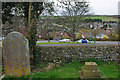
View from St Helen's churchyard
The church has good views in most directions except east.
Image: © Robin Webster
Taken: 3 Apr 2010
0.16 miles
9
Hangleton Lane
Once a farm track linking a couple of downland farms now a link road between the suburb of Hangleton and Hangleton Link Road, the A293, an access road for the Brighton by-pass.
Image: © Simon Carey
Taken: 7 Jan 2010
0.18 miles
10
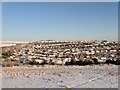
Hangleton
A view of the suburb from Benfield Valley Golf Course. The original settlement of Hangleton was deserted in the middle ages leaving just the church, manor and a few isolated farms in the area, Many of the latter failed in the interwar years and often the lure of property developers' money proved irresistible to the struggling farmers with the result that suburbs such as Hangleton began appearing on the eve of World War Two. Much of the valley below was completed post 1945 specifically in the 1960s and 70s when the last fields disappeared for good.
Image: © Simon Carey
Taken: 7 Jan 2010
0.20 miles