IMAGES TAKEN NEAR TO
Portland Avenue, HOVE, BN3 5NG
Introduction
This page details the photographs taken nearby to Portland Avenue, BN3 5NG by members of the Geograph project.
The Geograph project started in 2005 with the aim of publishing, organising and preserving representative images for every square kilometre of Great Britain, Ireland and the Isle of Man.

There are currently over 7.5m images from over14,400 individuals and you can help contribute to the project by visiting https://www.geograph.org.uk
Image Map
Images are licensed for reuse under creativecommons.org/licenses/by-sa/2.0
Notes
- Clicking on the map will re-center to the selected point.
- The higher the marker number, the further away the image location is from the centre of the postcode.
Image Listing (66 Images Found)
Images are licensed for reuse under creativecommons.org/licenses/by-sa/2.0
Image
Details
Distance
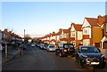
1
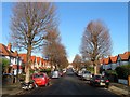
Portland Avenue, Aldrington, Hove
A residential road that links New Church Road, the B2066, to Portland Road. Originally part of a field called Great Golhards that was located in a detached portion of Portlsade parish that was acquired by Aldrington in 1883 by which point part of was used as a brick field. The road was laid out and developed in the early 1930s.
Image: © Simon Carey
Taken: 14 Dec 2016
0.01 miles
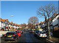
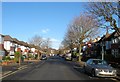
2
Mansfield Road, Aldrington, Hove
A residential road that links Portland Avenue to Portland Road. Originally part of a field called Great Golhards which was located within a detached portion of Portslade parish that was acquired by Aldrington in 1883 by which point part was used as a brick field. The road was laid out and developed in the early 1930s.
Image: © Simon Carey
Taken: 14 Dec 2016
0.04 miles
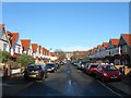
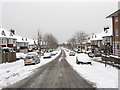
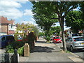
3
Woodhouse Road, Aldrington, Hove
A residential road that links Portland Avenue to Portland Road. Originally a field called Little Golhards that was located in a detached portion of Portslade parish that was acquired by Aldrington in 1883 by which point it was being used a brick field. Development occurred in the early 1930s with part of the road completed by the time of the 1932 OS map.
Image: © Simon Carey
Taken: 14 Dec 2016
0.07 miles
4
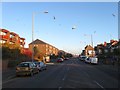
Portland Road, Hove
One of four east-west roads that run parallel to each other through the old parish of Aldrington, the others being Kingsway (A259), New Church Road (B2066) and Old Shoreham Road (A270). The road was laid out in the 1870s and developed gradually over the next forty or so years.
Image: © Simon Carey
Taken: 3 Dec 2016
0.09 miles
5
Jesmond Road, Aldrington, Hove
A residential road that heads south from Portland Road joining Rothbury Road at the junction with Mornington Crescent. Originally an open space called Old field in Aldrington's 1840 tithe map both this road and neighbouring Image were not developed until the 1930s.
Image: © Simon Carey
Taken: 3 Dec 2016
0.09 miles
6
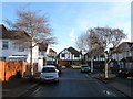
Woodhouse Road, Aldrington, Hove
A view of the road heading east from Portland Avenue before it turns north to Portland Road, see Image, with Woodhouse Close in view at the corner. The road in the foreground was once the site of Wish Cottage which was located in the south east corner of a detached portion of Portslade parish. The cottage was built sometime in the 19th century, it isn't marked on the 1813 OS map but does appear on Portslade's 1840 tithe map. The cottage survived until 1927 before it was demolished to make way for Woodhouse Road. See https://jackiedinnis.files.wordpress.com/2013/08/aldrington-park-copy.jpg with the cottage located on the right beneath the flag.
Image: © Simon Carey
Taken: 14 Dec 2016
0.10 miles
7
Coleman Avenue
Residential street linking Portland Road to New Church Road that was developed during the 1930s.
Image: © Simon Carey
Taken: 2 Dec 2010
0.11 miles
8
Coleman Avenue, Aldrington, Hove
A residential road that runs between New Church Road, the B2066, and Portland Road. The road follows the western boundary of an old field called West Laine in Aldrington's 1840 tithe map that later became Wish Brick Field who would supply much of the building material for the developing suburb. Consequently, the road was not laid out until the late 1920s and development only completed by the mid 1930s.
Image: © Simon Carey
Taken: 14 Dec 2016
0.12 miles
9
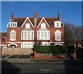
143-145, New Church Road, Aldrington, Hove
Built in the first decade of the 20th century for a number of years the only residences between St Leonard's and St Philip's churches, see https://jackiedinnis.files.wordpress.com/2013/08/aldrington-park-copy.jpg to get some idea of the isolation. Now located on the western corner of Portland Avenue.
Image: © Simon Carey
Taken: 14 Dec 2016
0.13 miles
10
New Church Road
One of Hove's longest at 2.3km (1.4 miles) and straightest roads, New Church Road runs from Portslade Boundary Road to Hove's Sackville Road
Image: © Paul Gillett
Taken: 26 May 2009
0.13 miles