IMAGES TAKEN NEAR TO
Boundary Road, HOVE, BN3 4EH
Introduction
This page details the photographs taken nearby to Boundary Road, BN3 4EH by members of the Geograph project.
The Geograph project started in 2005 with the aim of publishing, organising and preserving representative images for every square kilometre of Great Britain, Ireland and the Isle of Man.

There are currently over 7.5m images from over14,400 individuals and you can help contribute to the project by visiting https://www.geograph.org.uk
Image Map
Images are licensed for reuse under creativecommons.org/licenses/by-sa/2.0
Notes
- Clicking on the map will re-center to the selected point.
- The higher the marker number, the further away the image location is from the centre of the postcode.
Image Listing (169 Images Found)
Images are licensed for reuse under creativecommons.org/licenses/by-sa/2.0
Image
Details
Distance
1
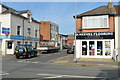
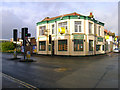
Station Road/Boundary Road
The B2194 is single road with two names, the houses on the left are Station Road, those on the right Boundary Road. In the early 19th century the road was known as Aldrington Drove or Red House Droveway and marked the parish boundary between Portslade and Hove. The coming of the railway and the construction of Portslade station meant the route's name was changed to Station Road which remained the case until 1895 when a dispute between the two councils over who was responsible for the upkeep resulted in a change which drew the boundary down the centre of the road and split responsibility in half. The eastern side's name was changed to Boundary Road in 1903 to avoid confusion regarding stations as Station Road, Hove did not lead to Hove station though Station Road, Portslade did lead to Portslade station. This state of affairs remains the same today throughout the entire length between the A259 and the A270 though north of Portslade station the western half becomes Carlton Terrace.
The road today is the main shopping street for Portslade though this was developed only from the 1930s onwards as the original road was built with upmarket Victorian villas and began life as a purely residential district. The building on the corner was the Halfway House a pub that was built before the growth of the residential area around it being named after its position between Brighton and Shoreham. Unfortunately it closed a couple of years ago and has now been converted into offices.
Image: © Simon Carey
Taken: 2 Dec 2010
0.01 miles
2
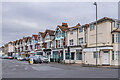
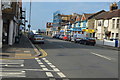
Boundary Road
Terrace of early 20th Century shops/houses, first shown on the 1912 25 inch map. When first laid out (the road here is marked on the 1879 6 inch map, but with development on the west side only), this was named Station Road, since it led to Portslade Station. However that side was in Portslade, with the eastern side (here) being in Hove. Since Hove Station was further east, having the road named Station Road was considered confusing and so the Hove side was renamed Boundary Road. As a result, we now have a road with different names according to the side of the road.
Image: © Ian Capper
Taken: 21 Jan 2022
0.02 miles
3
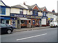
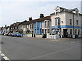
The Blue Anchor, Station Road
Local pub in Portslade's main shopping area.
Image: © Peter Holmes
Taken: 17 Mar 2012
0.02 miles
4
The Halfway House, Wellington Road
On the corner of Wellington Road (A259) and Station Road (B2194). Recently closed pub which would have been built to serve the residential areas to the west of it which were mostly removed in the 1950s. The pub has recently been closed and boarded up, its name referring to its siting between Brighton and Shoreham.
Image: © Simon Carey
Taken: 9 Dec 2007
0.02 miles
5

Building work on corner block
An overhaul of a rather run-down looking building.
Image: © Robin Webster
Taken: 23 Mar 2010
0.03 miles
6
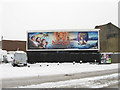
Who Left the Wardrobe Open?
Apt advertisement on Wellington Road, the A259, after 8-10 inches of snow were deposited on Brighton overnight. The billboard occupies the site of Belgrave Square built in the 1850s and demolished in the 1960s.
Image: © Simon Carey
Taken: 2 Dec 2010
0.03 miles
9
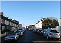
Seaford Road, Aldrington, Hove
A residential road that links St Leonard's Road to Boundary Road/Station Road, the B2194. The northern side was developed in the 1890s whilst the southern side was not completed until the first decade of the 20th century.
Image: © Simon Carey
Taken: 22 Dec 2016
0.03 miles