IMAGES TAKEN NEAR TO
Farm Road, HOVE, BN3 1GH
Introduction
This page details the photographs taken nearby to Farm Road, BN3 1GH by members of the Geograph project.
The Geograph project started in 2005 with the aim of publishing, organising and preserving representative images for every square kilometre of Great Britain, Ireland and the Isle of Man.

There are currently over 7.5m images from over14,400 individuals and you can help contribute to the project by visiting https://www.geograph.org.uk
Image Map
Images are licensed for reuse under creativecommons.org/licenses/by-sa/2.0
Notes
- Clicking on the map will re-center to the selected point.
- The higher the marker number, the further away the image location is from the centre of the postcode.
Image Listing (436 Images Found)
Images are licensed for reuse under creativecommons.org/licenses/by-sa/2.0
Image
Details
Distance
1
Farm Mews
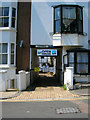
Housing lines the western side of Farm Road for its entire length. The space between Farm Road and Lansdowne Place has been filled with small mewses with access under the buildings. Originally used as service and stabling for the grander houses in Lansdowne Place they are now occupied by housing. The Open House sign refers to the current Brighton Festival which runs throughout May whereby artists are able to set up their own galleries showing their own work often in their own homes which are published in the Festival guide for those who wish to visit.
Image: © Simon Carey
Taken: 3 Jun 2007
0.02 miles
2
Lansdowne Mews
The entrance is next to the Coopers Cask Pub on Farm Road. Originally stables for the houses in Lansdowne Place, the backs of which are behind, this mews still retains businesses and services and has yet to be converted into housing.
Image: © Simon Carey
Taken: 3 Jun 2007
0.02 miles
3
Hove old fire station
Hove old fire station, 17/18a Farm Road, Hove, Brighton, East Sussex
Image: © Kevin Hale
Taken: 28 Jun 2010
0.03 miles
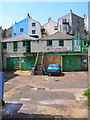
4
Garage to Let, Farm Road
Looking eastwards with the backs of the houses in Brunswick Place beyond. Farm Road is squeezed between the major developments of Brunswick and Lansdowne Place and once its original purpose as a route to the local farm was no more became a service road for the two estates.
Image: © Simon Carey
Taken: 3 Jun 2007
0.03 miles
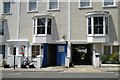
5
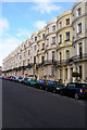
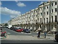
Lansdowne Place (Eastern Side)
Bow fronted terraced Victorian town houses erected during the 1850s as lower cost housing to the more upmarket Brunswick Square nearby. This part of Lansdowne Place is between Western Road and Lansdowne Road.
Image: © Simon Carey
Taken: 4 Nov 2007
0.04 miles
6
Barneys, Western Road
Takes up the bulk of shop space between Farm Road (to the left) and Brunswick Place (out of picture to the right).
Image: © Simon Carey
Taken: 3 Jun 2007
0.04 miles
7
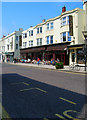
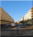
Brunswick Place
Built as part of the Brunswick development between 1824-29. Brunswick Place is the northward extension of Brunswick Square and the houses here were originally intended for the not quite so well off who couldn't afford the apartments by the sea. These days many are subdivided into flats and bedsits. Looking across Western Road, the B2066.
Image: © Simon Carey
Taken: 20 Jul 2009
0.04 miles
8
Cambridge Road Hove
Road off of Western Road
Image: © Paul Gillett
Taken: 26 May 2009
0.04 miles
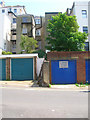
9
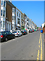
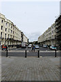
Farm Road
Squeezed between Brunswick Place and Lansdowne Place and originally the road to the local manor and farm. The western side is built up whereas the eastern part is a mixture of dwellings and garages.
Image: © Simon Carey
Taken: 3 Jun 2007
0.04 miles
10
Brunswick Place, Hove
Residential street that links Western Road to Lansdowne Road that was begun in 1822 but not completed until the 1840s when the whole of the eastern side was built. All buildings either side were listed in 1950 to prevent Hove Council from demolishing them.
Image: © Simon Carey
Taken: 11 Oct 2015
0.05 miles