IMAGES TAKEN NEAR TO
Tarner Road, BRIGHTON, BN2 9QT
Introduction
This page details the photographs taken nearby to Tarner Road, BN2 9QT by members of the Geograph project.
The Geograph project started in 2005 with the aim of publishing, organising and preserving representative images for every square kilometre of Great Britain, Ireland and the Isle of Man.

There are currently over 7.5m images from over14,400 individuals and you can help contribute to the project by visiting https://www.geograph.org.uk
Image Map
Images are licensed for reuse under creativecommons.org/licenses/by-sa/2.0
Notes
- Clicking on the map will re-center to the selected point.
- The higher the marker number, the further away the image location is from the centre of the postcode.
Image Listing (343 Images Found)
Images are licensed for reuse under creativecommons.org/licenses/by-sa/2.0
Image
Details
Distance
1
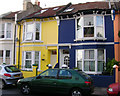
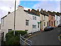
Tarner Road, Brighton
A residential road running from Sussex Street to Richmond Street that was built in 1931 as a council estate on a former field called Tarner Land.
Image: © Simon Carey
Taken: 1 Nov 2015
0.02 miles
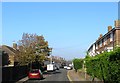
2
Windmill Terrace
Head east up Albion Hill then south into this road. This is near enough the summit 200 feet up from Old Steine. Windmill Terrace, named after a nearby windmill was built comparatively late in 1890 on land formerly worked by Chates Court Farm. The street links Richmond Street and Albion Hill as they almost converge beyond the summit, the whole length being viewed in the photograph.
Click on the link to take you to the next page. http://www.geograph.org.uk/photo/232016
Image: © Simon Carey
Taken: 1 Sep 2006
0.02 miles
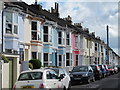
3
Elmore Road, Brighton
A residential road that runs from Sussex Street to Richmond Street that was built by the council in 1931 on a former open field known as Tarner Land that was used by Chates Farm as pasture, see Image
Image: © Simon Carey
Taken: 1 Nov 2015
0.04 miles
4
Windmill Street
Head west up Richmond Street then south down Windmill Street. Developed from 1854 onwards and near the site of two windmills. One to the south called Taylor's Mill that collapsed in 1862 and the other to the east known as Clifton Mill as it had been moved from Clifton Gardens in 1837 which was demolished in 1862.
Click on the link to take you to the next page. http://www.geograph.org.uk/photo/232034
Image: © Simon Carey
Taken: 1 Sep 2006
0.04 miles
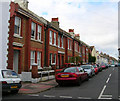
5
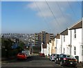
Richmond Street, Brighton
Once one of the steepest streets in Brighton that ran from Grand Parade to Queen's Park Road but has been truncated since the 1960s when the western end at the foot of the hill was renamed Richmond Parade and the rest ending at the junction with Elmore Road. The 1:5 incline necessitated the building of a wall across the road between Dinapore Street and Claremont Place to stop any runaway carts reaching the bottom of the street. The wall survived into the 1960s when it was removed with the rest of the street, see http://regencysociety-jamesgray.com/volume27/source/jg_27_080.html. The terrace on the right heading down to Image was built in the 1880s, see http://regencysociety-jamesgray.com/volume27/source/jg_27_052.html for a similar view taken around 1874 when the area was an open field used by Chates Farm.
The steepness of the hill can be vouched by the high rise block, Richmond Heights, which is ten storeys but only six can be seen in this view. In the far distance is the North laine area along with International House on the western slope which is located next door to Brighton Station. Further up the slope is the West Hill area of the city.
Image: © Simon Carey
Taken: 1 Nov 2015
0.04 miles
7
Windmill Street, Brighton
A residential street that runs between Sussex Street and Richmond Street that was developed in the 1870s and commemorates Taylor's Mill which stood at the top of Lennox Street adjacent to Sussex Street. It had been moved there in the 1840s from Kemp Town and was about to be moved again to the Warren Industrial School at Woodingdean when it collapsed in 1862.
Image: © Simon Carey
Taken: 1 Nov 2015
0.05 miles
8
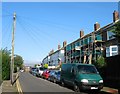
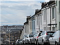
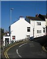
Richmond Street
Head north along Elmore Road until it turns east into Richmond Street once one of the steepest streets in Brighton with a gradient of 1:5. To the west of this point a wall was placed across the width of the street to stop runaway carts heading to the bottom. The house on the left, 34A Richmond Street is the last remaining building from Chates Farm that continued operating as a working dairy farm between 1858 and 1934 behind the row of houses in view despite being surrounded by an ever expanding urban area. For a view of an old image of the farm click on this link http://www.mybrightonandhove.org.uk/page_id__5531_path__0p115p192p824p.aspx
Click on the link to take you to the next page http://www.geograph.org.uk/photo/231698
Image: © Simon Carey
Taken: 1 Sep 2006
0.06 miles
9
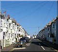
34a, Richmond Street, Brighton
Located at the corner of Richmond Street and Elmore Road the house predates the terrace on the right and juts out. It is the last remnant of Chates Farm which operated here until its closure in 1934, the last working farm within the old parish boundary of Brighton. It pastured its dairy herd in two fields; one bounded in a triangle of land formed by Liverpool Street, Albion Hill and Richmond Street; the other was located in a square field known as Tarner Land that was bounded by Apollo Terrace, Richmond Street, Windmill Street and Sussex Street. The former has largely been built on though an area of land is still used as allotments whilst the latter is now covered by an estate built by the council in 1931.
Image: © Simon Carey
Taken: 1 Nov 2015
0.06 miles