IMAGES TAKEN NEAR TO
Warningcamp, ARUNDEL, BN18 9QZ
Introduction
This page details the photographs taken nearby to BN18 9QZ by members of the Geograph project.
The Geograph project started in 2005 with the aim of publishing, organising and preserving representative images for every square kilometre of Great Britain, Ireland and the Isle of Man.

There are currently over 7.5m images from over14,400 individuals and you can help contribute to the project by visiting https://www.geograph.org.uk
Image Map
Images are licensed for reuse under creativecommons.org/licenses/by-sa/2.0
Notes
- Clicking on the map will re-center to the selected point.
- The higher the marker number, the further away the image location is from the centre of the postcode.
Image Listing (32 Images Found)
Images are licensed for reuse under creativecommons.org/licenses/by-sa/2.0
Image
Details
Distance
1
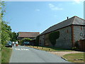
Flint Barn
the inappropriately named 'Norfolk Flint Barn' at Warningcamp nr Southern edge of grid square.
Image: © Chris Shaw
Taken: Unknown
0.04 miles
2
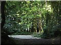
Site of Former Gravel Pit
The small wood off Burpham Road was originally part of the neighbouring Image and became a gravel pit in the first decade of the 20th century and continued in use until after the Second World War. The area is now a small plantation.
Image: © Simon Carey
Taken: 19 Aug 2013
0.04 miles
3
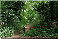
Warningcamp
The Monarch's Way, entering South Woodleighs at this point.
Image: © Peter Trimming
Taken: 9 Jun 2018
0.05 miles
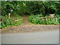
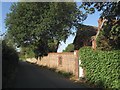
4
Warningcamp
Private parking area, on the edge of woodland.
Image: © Peter Trimming
Taken: 9 Jun 2018
0.05 miles
5
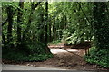
The Monarch's Way enters Angmering Park Estate
The route follows bridleway 2219 through woods at South Woodleighs.
Image: © Peter Holmes
Taken: 21 Jun 2008
0.05 miles
6
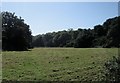
Shepherds Mead
The name of the field according to Warningcamp's 1840 tithe map viewed from Image The small valley heads eastwards via Image then continues into Image The woods in view are The Woodleighs on the left and South Woodleighs to the right.
Image: © Simon Carey
Taken: 20 Aug 2013
0.09 miles
7
Lower Common (2)
The name of the field according to Warningcamp's 1840 tithe map viewed from Burpham Road. A former medieval open field that survived up to its enclosure in 1812 it was initially divided into two large fields with the larger one seeing the construction of a number of dwellings from the 1860s onwards. One of those in view in the distance was Sefton Place which remained a family home until the 1920s when it briefly became a Roman Catholic prep school, an officer's quarters during the Second World War then a youth hostel in 1946. The hostel was closed in 2012 one of 8 closed and sold by the Youth Hostel Association in 2011. It is scheduled to be reopened as the Sussex Heritage Centre.
Image: © Simon Carey
Taken: 19 Aug 2013
0.09 miles
8
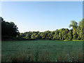
Fleet Mead (2)
The name of the field according to Warningcamp's 1840 tithe map that was known as Flick Mead on an 1809 enclosure map. Another field to the immediate north shares the same name, see Image The field is also the end of a small valley that begins with Image, continues with Image before crossing the Burpham Road, which was built in 1883, before heading out into the Arun flood plain. The woods in view are The Woodleighs to the left and South Woodleighs to the right.
Image: © Simon Carey
Taken: 20 Aug 2013
0.10 miles
9
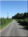
Burpham Road
The current road from Burpham to the A27 near Arundel was constructed in 1883 to make access between the two easier. Prior to that those wishing to travel between the two travelled via Warningcamp Hill and Blakehurst Lane. Here it crosses the flat lands between South Woodleighs and The Woodleighs.
Image: © Simon Carey
Taken: 20 Aug 2013
0.12 miles
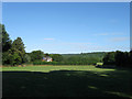
10
Warningcamp House
Viewed from Burpham Road the house was built in the 1860s on a plot on a former common field. Originally known as Woodleighs House it acquired its current name in the 1950s. The road in view was added in 1883 to give villagers in Burpham and Wepham a more direct route to the market town of Arundel.
Image: © Simon Carey
Taken: 19 Aug 2013
0.13 miles