1
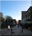
Ann Street, Brighton
Built in the 1840s as a residential road that connected London Road to Peel Street. The western end was demolished and truncated when the goods yard was extended around 1903 with the road ending at Fleet Street and New York Street. Much of the area was redeveloped in the early 1960s which included the reconstruction and expansion of St Bartholomew's Infants School on the left which required the compulsory purchasing of numbers 11-19. Number 19 had been the exotically named Mazeppa Inn from the 1860s until its closure in 1958 the pub being named after either a 17th century Ukrainian Cossack nobleman or Lord Byron's 1819 poem about said gentleman. At about the same time numbers 34-40 on the southern side were also removed but not replaced with housing until the 1990s with much of the area between new England Street and St Peter's Street becoming a car park. The imposing building on the left is St Bartholomew's church.
Image: © Simon Carey
Taken: 21 Nov 2015
0.01 miles
2
St Peters Street
Originally a small street that linked Cheapside to Ann Street. The original terrace cleared of tenants in the early 1970s though the houses remained for some time after whilst arguments went on about what was to built in its stead. They were eventually demolished and the street rebuilt in the early 1990s with a small open space opposite the terrace at the northern end next to St Bartholomews church.
See http://regencysociety-jamesgray.com/volume25/source/jg_25_252.html for a view taken in 1963.
Image: © Simon Carey
Taken: 31 Jul 2011
0.01 miles
3
Demolishing Ransoms
The end of an era for the household goods shop that has traded on the corner of Ann Street and Providence Place for over 40 years in the process of being demolished after the building became unstable. The shop still lives, however, moving one door down to number two.
Image: © Simon Carey
Taken: 30 Oct 2011
0.01 miles
4
St Bartholomew's church
Built in 1872-74 and opened in 1874, the church is said to have the dimensions of Noah's ark
Church website: http://www.stbartholomewsbrighton.org.uk/welcome.htm
Image: © Paul Gillett
Taken: 31 Jan 2010
0.01 miles
5
St Bartholomew's Church Ann Street Brighton
An England Parish Church within the Diocese of Chichester,St Bartholomew's is a world famous Fr Wagner church. There is some history here: http://www.stbartholomewsbrighton.org.uk/anearlyhistory.htm
Image: © PAUL FARMER
Taken: 22 Sep 2012
0.01 miles
6
Woolworths, London Road
London Road developed as a shopping area during Victorian times serving the houses of the railway workers between this street and the locomotive works. Woolworth's was erected in the 1930s and they remain one of the major chains on this road, however, many others have long gone and this shopping area is becoming a little run down.
Image: © Simon Carey
Taken: 1 Oct 2006
0.02 miles
7
St Peter's Street, Brighton
A residential street that connects Ann Street to Cheapside that was originally built in the 1840s but demolished in its entirety during the 1960s. The site remained empty until the 1990s when the northern terrace was built and the southern side left as a small garden.
Image: © Simon Carey
Taken: 21 Nov 2015
0.02 miles
8
Sculpture in Providence Place
Simple wooden sculpture, resembling the ribs of a boat.
Image: © Oliver Dixon
Taken: 11 Sep 2019
0.02 miles
9
Providence Place
The street originally ran behind the shops on London Road to the right from York Hill to Cheapside though the latter part to the immediate south was closed off to enable some of the larger stores to extend further back. St Bartholomews reputed to have been built to the same dimensions as Noah's ark provides the backdrop. See http://www.regencysociety-jamesgray.com/volume10a/source/jg_10a_083.html for an image taken at roughly the same spot in 1964.
Image: © Simon Carey
Taken: 31 Jul 2011
0.02 miles
10
New England Street
Originally the name only applied to the northern part of what was three separate streets. The middle section was New York Street and this part was Fleet Street all packed with terracing housing built in the 1850s to house the workers for the nearby locomotive works. The northern part was demolished in the late 1950s/early 1960s whilst this part went towards the end of the 1960s. To the left was the boundary with the goods yard which had been extended in 1905 but had become a giant car park by the 1980s. The rest was turned into small pockets of housing or office blocks and business premises. The old goods yard was finally redeveloped in the 2000s and with it a new access road to the west which was named Fleet Street leaving this section of New England Street now closed beyond the junction with Ann Street.
Image: © Simon Carey
Taken: 31 Jul 2011
0.02 miles


