IMAGES TAKEN NEAR TO
Rife Way, WORTHING, BN12 5JZ
Introduction
This page details the photographs taken nearby to Rife Way, BN12 5JZ by members of the Geograph project.
The Geograph project started in 2005 with the aim of publishing, organising and preserving representative images for every square kilometre of Great Britain, Ireland and the Isle of Man.

There are currently over 7.5m images from over14,400 individuals and you can help contribute to the project by visiting https://www.geograph.org.uk
Image Map
Images are licensed for reuse under creativecommons.org/licenses/by-sa/2.0
Notes
- Clicking on the map will re-center to the selected point.
- The higher the marker number, the further away the image location is from the centre of the postcode.
Image Listing (96 Images Found)
Images are licensed for reuse under creativecommons.org/licenses/by-sa/2.0
Image
Details
Distance
1
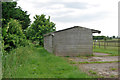
Stables by footpath 2118/1, Ferring
The not very popular path runs to the left behind the stables, which were not too popular at this time either.
Image: © Robin Webster
Taken: 20 Jun 2010
0.01 miles
2
Footpath junction and bridge, Ferring
The small bridge is over one of the many overgrown ditches in this area that drain into Ferring Rife.
Image: © Robin Webster
Taken: 20 Jun 2010
0.01 miles
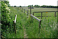
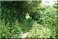
3
Footpath 2118/1, Ferring
A not greatly used path, largely duplicated by the residential road Meadow Way off to the right.
Image: © Robin Webster
Taken: 20 Jun 2010
0.02 miles
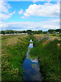
5
Ferring Rife
The rife bisects Onslow Caravan Park in the distance.
Image: © Robin Webster
Taken: 20 Jun 2010
0.06 miles
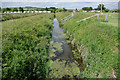
6
Ferring Rife
Viewed from the entrance to Ferring Country Centre with Image to the west and Image to the east.
Ferring Rife is small waterway that rises in Durrington and enters the sea via an outfall on the south western edge of Ferring parish. Rife is a local Sussex dialect word for a small river and the name is particularly numerous on the coastal plain between Worthing and Chichester. It is the eastern most example. Highdown Hill can be seen in the background.
Image: © Simon Carey
Taken: 6 Aug 2017
0.06 miles
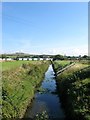
7
Ferring Rife
Rife is a local name for a small watercourse and is prevalent in the coastal plain area between here and Chichester Harbour. The stream rises from near Goring and enters the sea on the western side of Ferring. Much of it has been straightened and embanked over the centuries. To the left is Onslow Caravan Park whilst Highdown Hill provides the backdrop.
Image: © Simon Carey
Taken: 20 Jul 2008
0.07 miles
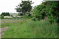
8
Footpath 2114/1, Ferring
A less popular section of the path, running between the back gardens of houses on Meadow Way to the right and Onslow Caravan Park to the left. An easier but less green route is to use Meadow Way.
Image: © Robin Webster
Taken: 20 Jun 2010
0.07 miles
9
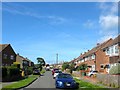
Meadow Way, Ferring
A residential road that links Onslow Drive to Rife Way that was built in the 1950s on the site of a former field called Ferring Common Field according to Ferring's 1837 tithe map.
Image: © Simon Carey
Taken: 6 Aug 2017
0.08 miles
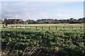
10
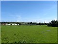
Mowed Mead
The name of the field according to Ferring's 1837 tithe map that is currently located between Ferring Rife to the west and the urbanised settlement of ferring to the east. Highdown Hill provides the backdrop.
Image: © Simon Carey
Taken: 6 Aug 2017
0.08 miles