IMAGES TAKEN NEAR TO
Church Lane, WORTHING, BN12 5HN
Introduction
This page details the photographs taken nearby to Church Lane, BN12 5HN by members of the Geograph project.
The Geograph project started in 2005 with the aim of publishing, organising and preserving representative images for every square kilometre of Great Britain, Ireland and the Isle of Man.

There are currently over 7.5m images from over14,400 individuals and you can help contribute to the project by visiting https://www.geograph.org.uk
Image Map
Images are licensed for reuse under creativecommons.org/licenses/by-sa/2.0
Notes
- Clicking on the map will re-center to the selected point.
- The higher the marker number, the further away the image location is from the centre of the postcode.
Image Listing (141 Images Found)
Images are licensed for reuse under creativecommons.org/licenses/by-sa/2.0
Image
Details
Distance
1
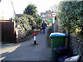
Walking the Dog
Twitten leading to Recreation Ground and linking Church Lane with Sea Lane. Public footpath 2119.
Image: © Peter Holmes
Taken: 14 Mar 2010
0.01 miles
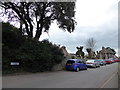
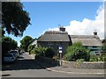
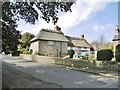
4
Church Lane
This is the heart of the old village and up to 1914 the southern edge leading onto fields between here and the beach. Holly Cottage, the first on the left, dates back to 1759. St Andrew's Church is out of picture to the right.
Image: © Simon Carey
Taken: 20 Jul 2008
0.03 miles
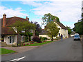
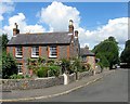
5
Maytree Cottage/Evergreen Cottage, Church Lane/Ferring Street, Ferring
Evergreen Cottage on the right dates from the 17th century and is located in Ferring Street. Maytree Cottage on the left was an 18th century extension and is officially addressed in Church Lane. Both are now separate dwellings.
Image: © Simon Carey
Taken: 6 Aug 2017
0.03 miles
6
Flint walled cottages, Ferring Street
Grade II listed buildings known as Smugglers Cottage and Smugglers Annex, at 3 and 3A Ferring Street, apparently used for storage of smuggled goods.
Image: © Peter Holmes
Taken: 13 Jan 2009
0.03 miles
7
Smugglers Cottage, Ferring Street, Ferring
A flint cottage and its former outbuilding beyond date from the late 18th/early 19th century and as the name suggests was used for storage during the smuggling era.
Image: © Simon Carey
Taken: 6 Aug 2017
0.03 miles
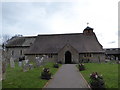
8
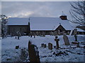
St Andrew's Church Ferring
The north side of St Andrew's in Church Lane viewed on a winter's morning.
Image: © Peter Holmes
Taken: 24 Jan 2007
0.03 miles
9
Ferring, thatched cottages
Maytree and Evergreen Cottages, on Church Lane. C17-18, Grade II listed by Historic England: https://historicengland.org.uk/listing/the-list/list-entry/1233832
Image: © Mike Faherty
Taken: 9 Mar 2019
0.03 miles
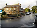
10
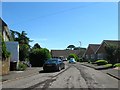
Glen Gardens, Ferring
A cul de sac off Ferring Street built in the latter part of the 1970s on the site of a former house called Glen Trool.
Image: © Simon Carey
Taken: 6 Aug 2017
0.03 miles