IMAGES TAKEN NEAR TO
The Lookout, PEACEHAVEN, BN10 7UG
Introduction
This page details the photographs taken nearby to The Lookout, BN10 7UG by members of the Geograph project.
The Geograph project started in 2005 with the aim of publishing, organising and preserving representative images for every square kilometre of Great Britain, Ireland and the Isle of Man.

There are currently over 7.5m images from over14,400 individuals and you can help contribute to the project by visiting https://www.geograph.org.uk
Image Map
Images are licensed for reuse under creativecommons.org/licenses/by-sa/2.0
Notes
- Clicking on the map will re-center to the selected point.
- The higher the marker number, the further away the image location is from the centre of the postcode.
Image Listing (26 Images Found)
Images are licensed for reuse under creativecommons.org/licenses/by-sa/2.0
Image
Details
Distance
1
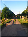
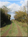
The Lookout
Taken from outside Bullock Down Reservoir looking towards the junction with Roderick Avenue the main access route for this road.
Image: © Simon Carey
Taken: 26 Dec 2008
0.06 miles
2
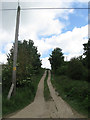
The Lookout
Taken from the point where it meets Downs Walk and the bridleway from Telscombe village. This is a public road though the car that has just left the driveway of the house on the right has made a point of heading eastwards towards the Roderick Avenue rather than use this muddy track. After heavy rains this road can become impassable.
Image: © Simon Carey
Taken: 26 Dec 2008
0.06 miles
3
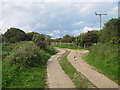
Roderick Avenue North
Unadopted roads north of Peacehaven.
Image: © Oast House Archive
Taken: 21 Jul 2012
0.10 miles
4
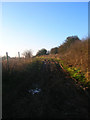
Downs Walk
Once the northern extent of Phyllis Avenue but has been renamed in the last decade. This is actually a public road though not recommended for those who wish to keep their vehicles clean. Saying that I've seen this road in a much worse condition than this. Taken from the point where it meets The Lookout.
Image: © Simon Carey
Taken: 26 Dec 2008
0.11 miles
5
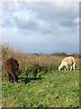
Llamas near Telscombe
A couple of llamas pasture next Image
Image: © Simon Carey
Taken: 27 Oct 2012
0.11 miles
6
Roderick Avenue North
Unadopted roads north of Peacehaven.
Image: © Oast House Archive
Taken: 21 Jul 2012
0.12 miles
7
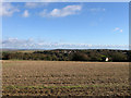
Farmland, North Peacehaven
Viewed from Image and looking back towards the northern edge of Peacehaven over what was for many centuries sheep pasture. The land between Telscombe Road and The Outlook retains some of the original settler vibe that characterised much of the town from its founding in the 1920s to the early 1960s, namely unmade roads, sparse dwellings and many overgrown plots awaiting use. The area itself is not part of the new South Downs National Park which probably means that sometime in the future it is likely to be developed. For now one can enjoy the views, though whether the chimney of the newly built household waste disposal unit at Newhaven can be included is a matter for conjecture. For the record it is just visible on the left of the picture.
Image: © Simon Carey
Taken: 27 Oct 2012
0.12 miles
8
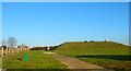
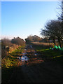
Bullock Down Reservoir
Covered reservoir on The Lookout.
Image: © Simon Carey
Taken: 26 Dec 2008
0.12 miles
9
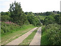
Downs Walk
Formerly the northern portion of Phyllis Avenue that was renamed in the 1980s when its middle section was effectively eradicating by the construction of the new housing estate around Heathy Brow. North of Telscombe Road it is little more than a muddy track that is impassable in winter. The hedgerow on the left marks the parochial boundary between Telscombe and what was Piddinghoe but is now Peacehaven.
Image: © Simon Carey
Taken: 27 Oct 2012
0.13 miles
10
Roderick Avenue North
The main access route for those living in The Lookout viewed from the crossroads with Valley Road. Roderick Avenue is the longest north-south road in Peacehaven stretching from the cliff tops to Bullock Down though it is no longer possible to drive its entire length. This section seems to have been added in the 1950s and is also a public footpath.
Image: © Simon Carey
Taken: 9 Jun 2012
0.13 miles