IMAGES TAKEN NEAR TO
Fairlight Avenue, PEACEHAVEN, BN10 7BL
Introduction
This page details the photographs taken nearby to Fairlight Avenue, BN10 7BL by members of the Geograph project.
The Geograph project started in 2005 with the aim of publishing, organising and preserving representative images for every square kilometre of Great Britain, Ireland and the Isle of Man.

There are currently over 7.5m images from over14,400 individuals and you can help contribute to the project by visiting https://www.geograph.org.uk
Image Map
Images are licensed for reuse under creativecommons.org/licenses/by-sa/2.0
Notes
- Clicking on the map will re-center to the selected point.
- The higher the marker number, the further away the image location is from the centre of the postcode.
Image Listing (20 Images Found)
Images are licensed for reuse under creativecommons.org/licenses/by-sa/2.0
Image
Details
Distance
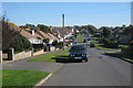
1
Telscombe Cliffs Way, Telscombe Cliffs
Image: © Stacey Harris
Taken: 19 Jun 2012
0.09 miles
2
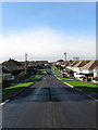
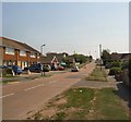
Grassmere Avenue, Telscombe Cliffs
Running west from Telscombe Cliffs Way and one of the original roads laid out in the first decade of the 20th century by the Cavendish Land Company. The road initially ended at the junction with Cliff Gardens but was extended a little further to meet a new road, Broomfield Avenue, when the neighbouring field known as Portobello Furlong was acquired then developed after the Second World War. Viewed from the junction with Fairlight Avenue.
Image: © Simon Carey
Taken: 27 Oct 2012
0.10 miles
3
Telscombe Cliffs Way, Telscombe Cliffs
Image: © Stacey Harris
Taken: 19 Jun 2012
0.10 miles
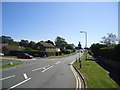
5
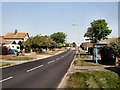
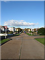
Telscombe Cliffs Way
Main road through Telscombe Cliffs stretching for over 1km
Image: © Paul Gillett
Taken: 23 Apr 2011
0.11 miles
6
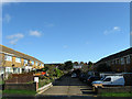
Clifton Way, Telscombe Cliffs
Small cul de sac off Telscombe Cliffs Way that was built in the late 1960s.
Image: © Simon Carey
Taken: 27 Oct 2012
0.12 miles
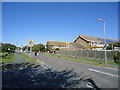
7
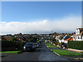
Cliff Gardens, Telscombe Cliffs
One of the original roads laid out by the Cavendish Land Company in the first decade of the 20th century. Viewed from its junction with Fairlight Avenue the road heads west then turns a right angle to head north to Grassmere Avenue. This shape was dictated by the then ownership of land by the building company who were unable to acquire a large neighbouring field called Portobello Furlong as it was owned by the coastguard.
Image: © Simon Carey
Taken: 27 Oct 2012
0.14 miles
8
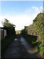
Drive to Kirby Farm, Telscombe Cliffs
The private track heads west off Telscombe Cliffs Way towards the farm, whose farmhouse roof is just visible over the hedge to the right. The farm seems to have replaced Warren Farm a little to the north sometime in the 1940s and worked the fields around the northern end of the settlement until the early 1980s when a large chunk were sold and developed into housing. The new route through the estate was named Kirby Drive in acknowledgement.
Image: © Simon Carey
Taken: 27 Oct 2012
0.18 miles
9
Central Avenue, Telscombe Cliffs
Looking towards the junction with St Peter's Avenue, see also Image
Image: © Simon Carey
Taken: 14 Oct 2012
0.18 miles