IMAGES TAKEN NEAR TO
Mayfield Road, BOURNEMOUTH, BH9 1TF
Introduction
This page details the photographs taken nearby to Mayfield Road, BH9 1TF by members of the Geograph project.
The Geograph project started in 2005 with the aim of publishing, organising and preserving representative images for every square kilometre of Great Britain, Ireland and the Isle of Man.

There are currently over 7.5m images from over14,400 individuals and you can help contribute to the project by visiting https://www.geograph.org.uk
Image Map
Images are licensed for reuse under creativecommons.org/licenses/by-sa/2.0
Notes
- Clicking on the map will re-center to the selected point.
- The higher the marker number, the further away the image location is from the centre of the postcode.
Image Listing (90 Images Found)
Images are licensed for reuse under creativecommons.org/licenses/by-sa/2.0
Image
Details
Distance
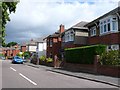
1
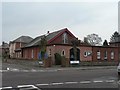
Moordown: Church of the Nazarene
A small church on the corner of Mayfield Road (ahead and behind) and Queen Mary Avenue (left and right). The 1975 Kelly's Directory lists it as the Andrew Vine Memorial Church of the Nazarene, but I can find no mention of Andrew Vine today.
Image: © Chris Downer
Taken: 24 Feb 2008
0.01 miles
2
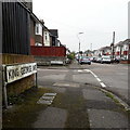
Moordown: King George Avenue
The middle of three parallel monarchical avenues in Moordown, sandwiched between King Edward and Queen Mary Avenues. They comprise typical Moordown housing - decent detached houses from the reign of Edward and the Georges in the 20th century.
The sign is the standard Bournemouth nameplate from the 1980s, affixed with tubular steel which protrudes at each side.
This is photo no.222 of a series of 453 in my coronavirus lockdown walking project:
See https://www.geograph.org.uk/article/My-2020-Coronavirus-Lockdown-walking-project for the complete set of photos.
Image: © Chris Downer
Taken: 18 Apr 2020
0.03 miles
3
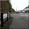
Moordown: Mayfield Road
Mayfield Road comes towards the camera from Coronation Road and crosses the three 'royal' avenues – Queen Mary, King George and King Edward – before turning a slight bend to end on Malvern Road. That last segment, distant behind us, was called Clarkson Road until about the mid-1930s.
The sign is a modern one, from 2010-15 when this more modern, abstract emblem rather than the traditional town coat of arms as the working logo of the council.
This is photo no.265 of a series of 453 in my coronavirus lockdown walking project:
See https://www.geograph.org.uk/article/My-2020-Coronavirus-Lockdown-walking-project for the complete set of photos.
Image: © Chris Downer
Taken: 18 Apr 2020
0.03 miles
4
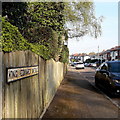
Moordown: King Edward Avenue
One of three consecutive monarchical avenues in Moordown, King George and Queen Mary Avenues being parallel to the south. They comprise typical Moordown housing - decent detached houses from the reign of Edward and the Georges in the 20th century.
The sign is an old cast-iron one from the 1950s, not exactly a rarity but nice to see surviving, refixed to a more modern fence.
This is photo no.221 of a series of 453 in my coronavirus lockdown walking project:
See https://www.geograph.org.uk/article/My-2020-Coronavirus-Lockdown-walking-project for the complete set of photos.
Image: © Chris Downer
Taken: 12 Apr 2020
0.09 miles
5
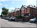
Coronation Avenue Bournemouth
View east along this quiet residential street of solidly built victorian red brick houses.
Image: © Nigel Mykura
Taken: 28 Aug 2009
0.10 miles
6
Bournemouth : Winton - Coronation Avenue
Image: © Lewis Clarke
Taken: 26 Apr 2009
0.10 miles
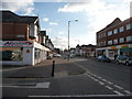
7
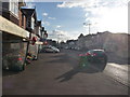
Bournemouth : Moordown - Wimborne Road
This florists has her love heart shaped balloons out ready to sell some flowers to those unfortunate enough to need to buy them this weekend.
Image: © Lewis Clarke
Taken: 11 Feb 2010
0.10 miles
8
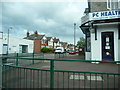
Bournemouth : Moordown - Moordown Clinic
An NHS run clinic which has a lot of stop smoking signs on it, as well as some of the other services it provides.
Image: © Lewis Clarke
Taken: 11 Feb 2010
0.11 miles
9
Endfield Road, Bournemouth
This is the view south of these 1930's houses in Endfield Rd close to the junction with Coronation Avenue.
Image: © Nigel Mykura
Taken: 28 Aug 2009
0.11 miles
10
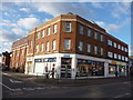
Bournemouth : Moordown - Wimborne Road
More shops on this road including Access Lock and Key, Dasco and Pamir Pizza.
Image: © Lewis Clarke
Taken: 11 Feb 2010
0.11 miles