IMAGES TAKEN NEAR TO
Broad Avenue, BOURNEMOUTH, BH8 9HF
Introduction
This page details the photographs taken nearby to Broad Avenue, BH8 9HF by members of the Geograph project.
The Geograph project started in 2005 with the aim of publishing, organising and preserving representative images for every square kilometre of Great Britain, Ireland and the Isle of Man.

There are currently over 7.5m images from over14,400 individuals and you can help contribute to the project by visiting https://www.geograph.org.uk
Image Map
Images are licensed for reuse under creativecommons.org/licenses/by-sa/2.0
Notes
- Clicking on the map will re-center to the selected point.
- The higher the marker number, the further away the image location is from the centre of the postcode.
Image Listing (49 Images Found)
Images are licensed for reuse under creativecommons.org/licenses/by-sa/2.0
Image
Details
Distance
1
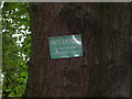
Strouden, sign
Sign from less dog-friendly times, nailed to a tree in Image Locals say that it is here because there used to be an entrance nearby to Image Ironically, when out walking here (with my dog) this morning, the only other people around were dog-walkers!
Image: © Mike Faherty
Taken: 21 Jun 2009
0.05 miles
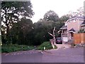
2
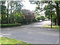
Hadden Avenue, Bournemouth
The junction of Hadden Avenue with Broad Avenue
Image: © Nigel Mykura
Taken: 13 Sep 2008
0.05 miles
3
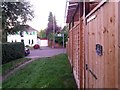
Queen?s Park: a house?s side entrance onto footpath K04
This short public footpath - 27m in length - leads from between 17 and 19 Bower Road into the wooded edge of Strouden public open space. We see it here arriving onto Bower Road, with a side gate from no.17 opening onto the path.
See Image for the view along the path from across the road, and Image for the view behind us into the wood.
Image: © Chris Downer
Taken: 5 Oct 2016
0.08 miles
4
Queen?s Park: footpath K04 from Bower Road
This short public footpath - 27m in length - leads from between 17 and 19 Bower Road into the wooded edge of Strouden public open space.
See Image for the view onto the road from along the path, with links to a couple of other photos on the route.
Image: © Chris Downer
Taken: 5 Oct 2016
0.09 miles
5
Queen?s Park: bright orange arrow by footpath K04
We look along this short public footpath from Bower Road as it arrives on the wooded fringes of Strouden public open space.
Bottom right, a bright orange arrow has been painted on the ground - presumably a waymark for a cross country run or similar.
See Image for the view into the woods from the path ahead, with links to a couple more photos of the public footpath.
Image: © Chris Downer
Taken: 5 Oct 2016
0.10 miles
6
Queen?s Park: footpath K04 reaches the woods
This public footpath is a very short one - at 27m in length - and it leads from Bower Road into the wooded edge of Strouden public open space. We see it here arriving into the woods, between the back gardens of nos. 17 and 19 Bower Road.
See Image for the view onto the path from just ahead, and Image for a view onto Bower Road, behind us.
Image: © Chris Downer
Taken: 5 Oct 2016
0.10 miles
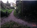
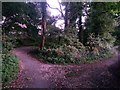
7
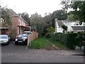
Queen?s Park: the end of Broad Avenue
Broad Avenue is a suburban street which follows the course of a historic path, before the suburbs were built. The historical path continues ahead as a public footpath, K48, while another footpath, K18, also leads ahead from here to Wordsworth Avenue.
Vehicles here just turn the bend into Normanhurst Avenue, which heads to our immediate right.
See Image for a photo just along the path ahead, with links to further pictures along both footpaths.
Image: © Chris Downer
Taken: 5 Oct 2016
0.11 miles
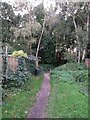
8
Strouden: the start of footpaths K18 and K48
Looking along the start of public footpath K48 (left), which is the historic route of what is now Broad Avenue at the southern end (just behind us) and Castle Gate Close at the northwest end - this referring to a time before these suburbs of the town were built.
Meanwhile, the wider track to the right is footpath K18 leading to Wordsworth Avenue and a modern path towards Bradpole Road.
See:
Image for the view towards us from path K48 ahead;
Image for the next view on the path K18, right
(each with links to further pictures on the route); and
Image for the view to here from the end of Broad Avenue, behind us.
Image: © Chris Downer
Taken: 5 Oct 2016
0.12 miles
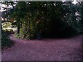
9
Strouden: footpath K48 meets up with footpath K18
Looking along a public footpath which is the historic route of what is now Broad Avenue at the southern end and Castle Gate Close at the northwest end - this referring to a time before these suburbs of the town were built.
It bears left just here to meet up with another footpath, K18 through the woods to the left, and just up to the right is the end of Broad Avenue mentioned above.
See Image for the next view on the path behind us, and Image for the next view on the path ahead - each with links to further pictures along the routes mentioned.
Image: © Chris Downer
Taken: 5 Oct 2016
0.12 miles
10
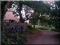
Strouden: graffitied fence on footpath K18
This public footpath, from Wordsworth Avenue, is seen here approaching its western end. The rear fence of the last house in Normanhurst Avenue has been daubed in graffiti. Just ahead, another path, K48, heads right to Mallard Road.
See Image for the next view on the path just ahead, and Image for the next view on the path behind us - each with links to further photos on the mentioned routes.
Image: © Chris Downer
Taken: 5 Oct 2016
0.12 miles