IMAGES TAKEN NEAR TO
St. Pauls Lane, BOURNEMOUTH, BH8 8AJ
Introduction
This page details the photographs taken nearby to St. Pauls Lane, BH8 8AJ by members of the Geograph project.
The Geograph project started in 2005 with the aim of publishing, organising and preserving representative images for every square kilometre of Great Britain, Ireland and the Isle of Man.

There are currently over 7.5m images from over14,400 individuals and you can help contribute to the project by visiting https://www.geograph.org.uk
Image Map
Images are licensed for reuse under creativecommons.org/licenses/by-sa/2.0
Notes
- Clicking on the map will re-center to the selected point.
- The higher the marker number, the further away the image location is from the centre of the postcode.
Image Listing (519 Images Found)
Images are licensed for reuse under creativecommons.org/licenses/by-sa/2.0
Image
Details
Distance
1
Bournemouth: St. Paul?s Night Shelter
This building, in St. Paul's Lane, is pretty much the last remaining building in the immediate area which gives any impression of an industrial past. It is surrounded by many 1960s and more modern buildings, a long-time vacant site, and the town centre by-pass from the late 70s. It is now used as a night shelter for the homeless.
The name St. Paul's Lane, and the dual carriageway to the north called St. Paul's Road, remind us of the former St.Paul's parish church and primary school, which in the early 1980s gave way to the Asda supermarket and travel interchange.
Image: © Chris Downer
Taken: 17 Oct 2008
0.01 miles
2
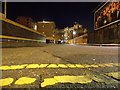
Bournemouth: the dead end of St. Paul?s Lane
Looking along St. Paul's Lane from ground level at its northern end. St. Paul's Lane is just a small back-street in the town's main business district, although it was a thoroughfare until the 1970s when the town's main road approaches were constructed.
In this picture, the advertisement hoarding on the right (for an upcoming film) shields what has been a vacant building plot for many, many years. On the immediate left is a tall wall around the grounds of the McCarthy & Stone building (Image).
More distant is Cranborne House (Image), one of the University's many student accommodation blocks, while on the left is Image
A few inches below us are the double yellow lines at the end of the carriageway, but pedestrian access is available to the pavement of St. Paul's Road running left-right immediately behind us. The route is physically blocked off to vehicles by a row of concrete posts.
The not-quite-new moon is just visible in light cloud above Cranborne House.
Image: © Chris Downer
Taken: 24 Dec 2014
0.02 miles
4
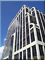
Bournemouth: shapely office block
The headquarters of McCarthy & Stone, who specialise in homes for those of retirement age.
Image: © Chris Downer
Taken: 15 Jul 2007
0.02 miles
5
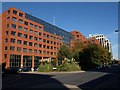
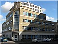
Holland House, Bournemouth
This large office block on Oxford Road is the home the Inland Revenue. On the right, on St Paul's Road, is Homelife House, shown in Image and Image
Image: © Derek Harper
Taken: 13 Oct 2009
0.03 miles
7
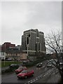
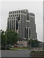
Homelife House, Bournemouth
Another of Bournemouth's iconic buildings, built for McCarthy & Stone; known locally as the Jelly Mould; as seen from ASDA carpark.
http://www.oursouthwest.com/SWImages/Bournemouth/bourn.htm
Image: © Mike Faherty
Taken: 13 Dec 2008
0.04 miles
8
Bournemouth: path between Lansdowne and St. Paul?s Roads
Lansdowne Road has no direct access to St. Paul's Road for vehicles, but this path provides a link for pedestrians. The ASDA store is in the distance, left.
Image: © Chris Downer
Taken: 2 Feb 2009
0.04 miles
9
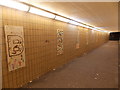
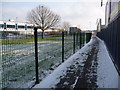
Bournemouth: subway under St. Paul?s Road
The subway leads to the Asda supermarket and the railway and coach stations. Thirteen panels on the wall spell out the word Bournemouth (with a spare at each end) and are embellished with painted handprints.
Image: © Chris Downer
Taken: 24 Dec 2014
0.05 miles
10
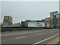
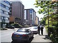
Advertising hoarding in Lansdowne Road
Image: © Basher Eyre
Taken: 20 Aug 2010
0.06 miles