IMAGES TAKEN NEAR TO
Cowdrey Gardens, BOURNEMOUTH, BH8 0LU
Introduction
This page details the photographs taken nearby to Cowdrey Gardens, BH8 0LU by members of the Geograph project.
The Geograph project started in 2005 with the aim of publishing, organising and preserving representative images for every square kilometre of Great Britain, Ireland and the Isle of Man.

There are currently over 7.5m images from over14,400 individuals and you can help contribute to the project by visiting https://www.geograph.org.uk
Image Map
Images are licensed for reuse under creativecommons.org/licenses/by-sa/2.0
Notes
- Clicking on the map will re-center to the selected point.
- The higher the marker number, the further away the image location is from the centre of the postcode.
Image Listing (47 Images Found)
Images are licensed for reuse under creativecommons.org/licenses/by-sa/2.0
Image
Details
Distance
1
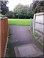
Strouden: footpath K38 arrives on Woodbury Avenue
Looking down this short public footpath from Barrow Way, at its emergence onto the realigned segment of Woodbury Avenue.
See:
Image for the view towards us from the bottom of the path;
Image for a wider view, including more discussion on the realignment of Woodbury Avenue; and
Image for the view towards the path from behind us on Barrow Way.
Image: © Chris Downer
Taken: 16 Oct 2016
0.07 miles
2
Strouden: across the old and new courses of Woodbury Avenue
Looking across this main route onto the Townsend housing estate - the modern alignment of the road, foreground, was put in perhaps 40 or 50 years ago, while at this point the original, slightly meandering course of the lane is beyond, forming a short service road to the few houses nearest it.
Beyond, we see the short public footpath, number K38, up to the more modern Barrow Way - see Image for a closer view of the footpath.
Image: © Chris Downer
Taken: 16 Oct 2016
0.07 miles
3
Strouden: footpath K38 from Woodbury Avenue
Looking across the original course of Woodbury Avenue up this short path to Barrow Way.
See Image for a wider view, including more discussion on the realignment of Woodbury Avenue, and Image for the view towards us from midway along the path.
Image: © Chris Downer
Taken: 16 Oct 2016
0.08 miles
4
Strouden: footpath K38 from Barrow Way
Looking along the start of this short path as it diverges from the pavement of Barrow Way. The far end of the path is also visible, on Woodbury Avenue.
See Image for a view of Woodbury Avenue from midway along the path.
Image: © Chris Downer
Taken: 16 Oct 2016
0.08 miles
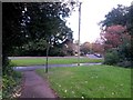
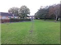
5
Townsend: footpath K36 reaches the open space
This short public footpath leads from Ibbertson Way onto the public open space behind the houses. Here, we look onto the open space from the end of the footpath.
See Image for the view towards us from ahead, and Image for the view behind us.
Image: © Chris Downer
Taken: 16 Oct 2016
0.11 miles
6
Townsend: footpath K36 to Ibbertson Way
This short public footpath leads from Ibbertson Way onto the public open space behind the houses. Here, we look onto the start of the path from the open space.
See Image for the view towards us from a little way along the path.
Image: © Chris Downer
Taken: 16 Oct 2016
0.11 miles
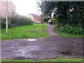
7
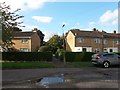
Townsend: footpath K36 from Ibbertson Way
Looking across the carriageway of Ibbertson Way and along this short public footpath, which leads onto the public open space behind the houses.
See Image for the view along the path from by the lamppost.
Image: © Chris Downer
Taken: 16 Oct 2016
0.12 miles
8
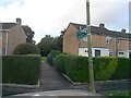
Townsend: footpath K36 is signposted to Open Space
Looking along this short public footpath, which leads from Ibbertson Way onto the public open space behind the houses.
See Image for the wider view from across the road behind us, and Image for the view towards us from along the path.
Image: © Chris Downer
Taken: 16 Oct 2016
0.12 miles
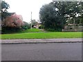
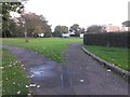
9
Townsend: footpath K47 towards Ibbertson Road
A public right of way, footpath K47, heads towards us from Ibbertson Road to cut across the broad triangular grass area and meet Throop Road. There is a tarmac surface at this end, as can be seen, but this fizzles out midway across the grass.
The course of the right of way appears to be mapped dead-straight, behind us, through what is now a car park for a neighbouring block of flats - see Image for the view towards us from ahead.
Meanwhile, see Image for the view from the corner of the car park behind us.
Image: © Chris Downer
Taken: 16 Oct 2016
0.12 miles
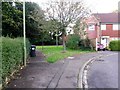
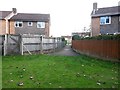
10
Townsend: footpath K47 leaves Ibbertson Road
The pavement of Ibbertson Road, left, skirts a tree out of picture, while another pavement heads right to pass the frontages of some bungalows.
Meanwhile, a public right of way, footpath K47, heads directly ahead to cut across the triangular grass area and meet Throop Road.
The course of the right of way appears to be mapped dead-straight, through what is now a car park for the distant block of flats. There is a tarmac surface at this end, as can be seen, but this fizzles out midway across the grass.
See Image for the next photo on the course of the public footpath.
Image: © Chris Downer
Taken: 16 Oct 2016
0.12 miles