IMAGES TAKEN NEAR TO
Harewood Avenue, BOURNEMOUTH, BH7 6NJ
Introduction
This page details the photographs taken nearby to Harewood Avenue, BH7 6NJ by members of the Geograph project.
The Geograph project started in 2005 with the aim of publishing, organising and preserving representative images for every square kilometre of Great Britain, Ireland and the Isle of Man.

There are currently over 7.5m images from over14,400 individuals and you can help contribute to the project by visiting https://www.geograph.org.uk
Image Map
Images are licensed for reuse under creativecommons.org/licenses/by-sa/2.0
Notes
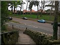
- Clicking on the map will re-center to the selected point.
- The higher the marker number, the further away the image location is from the centre of the postcode.
Image Listing (102 Images Found)
Images are licensed for reuse under creativecommons.org/licenses/by-sa/2.0
Image
Details
Distance
1
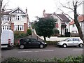
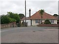
Boscombe East: across Harewood Avenue to footpath J08
The view across Harewood Avenue is slightly interrupted by parked cars, but across the road is a public footpath leading steeply between two houses to the dead end of Lascelles Road.
See Image for a view up the path from the pavement, and links to further photos along the route.
Image: © Chris Downer
Taken: 25 Feb 2017
0.02 miles
2
Boscombe East: footpath J08 to Lascelles Road
This public footpath leads quite steeply between two houses from here on Harewood Avenue to the dead end of Lascelles Road.
See Image for a wider view from across the road behind us, and Image for the view towards us from ahead, with links to further photos along the route.
Image: © Chris Downer
Taken: 25 Feb 2017
0.02 miles
3
Boscombe East: downhill on footpath J08
This public footpath leads quite steeply between two houses from the dead end of Lascelles Road onto Harewood Avenue, ahead of us.
See Image for a view towards us from the bottom of the path, and Image for the uphill view behind us.
Image: © Chris Downer
Taken: 25 Feb 2017
0.02 miles
4
Boscombe East: footpath J08 reaches Lascelles Road
This public footpath leads quite steeply from Harewood Avenue and is seen here as it comes out on the dead end of Lascelles Road.
See Image for the view down the path from the top, and Image for the next view on the path behind us.
Image: © Chris Downer
Taken: 25 Feb 2017
0.03 miles
5
Boscombe East: footpath J08 from Lascelles Road
This short public footpath leads quite steeply from here at the dead end of Lascelles Road, bound for Harewood Avenue.
See Image for the next view on the path.
Image: © Chris Downer
Taken: 25 Feb 2017
0.03 miles
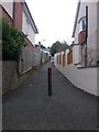
6
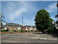
Swanmore Road, Bournemouth
Swanmore Road is a residential road in the suburbs of Bournemouth.
Image: © Malc McDonald
Taken: 21 Jun 2022
0.08 miles
7
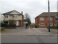
Boscombe East: footpath J10 from Harewood Avenue
This public footpath is essentially a rear access driveway for the shops and flats of even numbers 1054-1082 Christchurch Road (to our right) - from Harewood Avenue to Waltham Road.
We see it here from the Harewood Avenue end. The block of flats to the right are numbered 2a and the house is number 2.
See Image for the next view along the path.
Image: © Chris Downer
Taken: 25 Feb 2017
0.08 miles
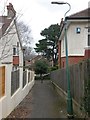
8
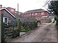
Boscombe East: a small back yard on footpath J10
This public footpath is essentially a rear access driveway for the shops and flats of even numbers 1054-1082 Christchurch Road (to our left) - from Harewood Avenue to Waltham Road.
We see it here as it heads uphill towards Harewood Avenue, with the back garden of number 1046 on our left, rather unusual in that the other rear yards are mainly parking areas.
See Image for the view down from Harewood Avenue ahead, and Image for the next view on the path behind us.
Image: © Chris Downer
Taken: 25 Feb 2017
0.08 miles
9
Pokesdown: down the steps on footpath J09
The driveway and churchyard path of the parish church of St. James the Greater form public footpath J09, cutting off the corner from King's Park to the main Christchurch Road.
Here, we look down from the churchyard gate onto the final bit of path, leading down to King's Park Drive and the odd side turn of Spurgeon Road.
(The zig-zag 'School Keep Clear' markings are there because the school is situated in the same grounds as the church, and this is a route used by pupils.)
See Image for the view up the steps from the grass ahead, and Image for the next view on the path behind us, with links to further photos along the route.
Image: © Chris Downer
Taken: 25 Feb 2017
0.09 miles
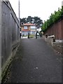
10
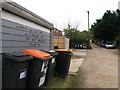
Boscombe East: do not obstruct this garage on footpath U10
This public footpath is essentially a rear access driveway for the shops and flats of even numbers 1054-1082 Christchurch Road (to our left) - from Harewood Avenue to Waltham Road.
The garage on our left, midway along the driveway, asks not to be obstructed - no vehicles are doing so, but the wheelie bins aren't taking any notice.
See Image for the next view on the path ahead, and Image for the next view on the path behind us.
Image: © Chris Downer
Taken: 25 Feb 2017
0.09 miles