IMAGES TAKEN NEAR TO
Southbourne Road, BOURNEMOUTH, BH6 5NS
Introduction
This page details the photographs taken nearby to Southbourne Road, BH6 5NS by members of the Geograph project.
The Geograph project started in 2005 with the aim of publishing, organising and preserving representative images for every square kilometre of Great Britain, Ireland and the Isle of Man.

There are currently over 7.5m images from over14,400 individuals and you can help contribute to the project by visiting https://www.geograph.org.uk
Image Map (Loading...)


Getting Data...Please wait
Leaflet Map data © OpenStreetMap
Images are licensed for reuse under creativecommons.org/licenses/by-sa/2.0
Notes
- Clicking on the map will re-center to the selected point.
- The higher the marker number, the further away the image location is from the centre of the postcode.
Image Listing (137 Images Found)
Images are licensed for reuse under creativecommons.org/licenses/by-sa/2.0
Image
Details
Distance
1
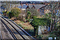
WWII defences in the environs of Bournemouth & Christchurch: Pokesdown - pillbox (1)
-
Pillbox (unclassified): DoB ID: e11458
View from the railway bridge in Southbourne Road of a square unidentified pillbox on the S side of the railway embankment.
Image
Image: © Mike Searle
Taken: 4 Mar 2016
0.05 miles
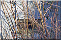
2
WWII defences in the environs of Bournemouth & Christchurch: Pokesdown - pillbox (2)
-
Pillbox (unclassified): DoB ID: e11458
A telephoto view from Southbourne Road railway bridge of the square, ivy covered pillbox on the S side of the railway embankment.
Image
Image: © Mike Searle
Taken: 4 Mar 2016
0.05 miles
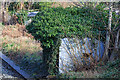
3
WWII defences in the environs of Bournemouth & Christchurch: Pokesdown - pillbox (3)
-
Pillbox (unclassified): DoB ID: e11458
In case anyone doubts this is a pillbox, I've included this view of the embrasure on the W side that despite the screen of vegetation in front of it, is identifiable nonetheless as a gun loop, and not a window!
Image
Image: © Mike Searle
Taken: 4 Mar 2016
0.05 miles
4
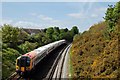
Railway Track at Southbourne
The London Waterloo to Bournemouth train on the stretch of track between the road bridge on Southbourne Road, Southbourne and Pokesdown Station.
The houses on the left are on Stourvale Road, Pokesdown
Image: © Elaine M Findlay
Taken: 2 May 2009
0.05 miles
5
Pokesdown: footpath J09 reaches Christchurch Road
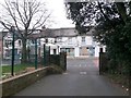
The driveway and churchyard path of the parish church of St. James the Greater form this public footpath, J09, cutting off the corner from King's Park to the main Christchurch Road.
Here, we see the church driveway and therefore the public right of way as it arrives on Christchurch Road.
See Image for the view towards us from across the road, and Image for the next view on the path behind us, with links to further photos along the route.
Image: © Chris Downer
Taken: 25 Feb 2017
0.06 miles
6
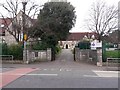
Pokesdown: footpath J09 is the church driveway
Looking across the main Christchurch Road towards the parish church of St. James the Greater, whose driveway and churchyard path form public footpath J09 to King's Park. Also visible in the picture is St. James' CE Primary School (left) and its playground which is to the right.
The plaques either side of the gateway are a memorial to the war dead of the parish; there is a more formal memorial in the churchyard, too.
See Image for the next view along the public right of way, with links to further photos along the route.
Image: © Chris Downer
Taken: 25 Feb 2017
0.07 miles
7
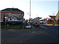
Pokesdown: postbox № BH7 25, Christchurch Road
This postbox stands on the corner of Connaught Road, a short cul-de-sac. Immediately behind it is the sign welcoming motorists to Pokesdown.
Image: © Chris Downer
Taken: 28 Dec 2008
0.07 miles
8

Pokesdown United Reformed Church
Grade 2 listed building erected in 1820.
Image: © Michael FORD
Taken: Unknown
0.07 miles
9

Southbourne: towards Stourvale Road on footpath H01
This narrow passageway forms a public footpath to the dead end of Hampden Lane (behind us), a surprisingly rural little side-street now much hemmed in by Bournemouth's suburbia.
See Image for the view up the path from the road ahead, and Image for the next view on the path behind us - with links to further photos all along its route and along Hampden Lane itself.
Image: © Chris Downer
Taken: 21 Jul 2016
0.08 miles
10

Southbourne: footpath H01 on the straight and narrow
This narrow passageway forms a public footpath to the dead end of Hampden Lane (behind us), a surprisingly rural little side-street now much hemmed in by Bournemouth's suburbia. We see it here on the way to Stourvale Road - a straight segment having just turned a left-hand bend.
See Image for the view on the path ahead, and Image for the next view behind us - with links to further photos all along its route and along Hampden Lane itself.
Image: © Chris Downer
Taken: 21 Jul 2016
0.08 miles