IMAGES TAKEN NEAR TO
Riverside Road, BOURNEMOUTH, BH6 5NN
Introduction
This page details the photographs taken nearby to Riverside Road, BH6 5NN by members of the Geograph project.
The Geograph project started in 2005 with the aim of publishing, organising and preserving representative images for every square kilometre of Great Britain, Ireland and the Isle of Man.

There are currently over 7.5m images from over14,400 individuals and you can help contribute to the project by visiting https://www.geograph.org.uk
Image Map
Images are licensed for reuse under creativecommons.org/licenses/by-sa/2.0
Notes
- Clicking on the map will re-center to the selected point.
- The higher the marker number, the further away the image location is from the centre of the postcode.
Image Listing (120 Images Found)
Images are licensed for reuse under creativecommons.org/licenses/by-sa/2.0
Image
Details
Distance
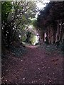
1
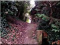
Tuckton: footpath I18 from the riverbank
This short public footpath leads from the dead end of Riverside Lane a short distance to the riverbank, which is just a few yards behind us, although there is no onward access along the river.
A small outflow pipe emerges alongside us, creating a tiny stream emptying into the river.
See Image for the view of the river behind us, and Image for the next view on the path ahead, with links to further photos on the route.
Image: © Chris Downer
Taken: 24 Sep 2016
0.03 miles
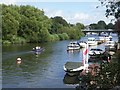
2
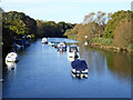
River Stour above Tuckton Bridge
The river is navigable for some way up for small launches.
Image: © Robin Webster
Taken: 6 Nov 2016
0.03 miles
3
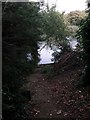
Tuckton: footpath I18 reaches the River Stour
This short public footpath leads from the dead end of Riverside Lane to the riverbank, and - as can be seen here - there is no onward access alongside the river in either direction.
See Image for the view up the path behind us, with links to further photos on the route.
Image: © Chris Downer
Taken: 24 Sep 2016
0.03 miles
4
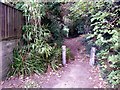
Tuckton: the start of footpath I18
This short public footpath leads from the dead end of Riverside Lane a short distance to the riverbank.
See Image for a wider view from behind us, and Image for the next view along the path ahead, with links to further photos on the route.
Image: © Chris Downer
Taken: 24 Sep 2016
0.03 miles
5
Tuckton: midway along footpath I18
This short public footpath comes down from Riverside Lane (ahead) to the riverbank which is a few yards behind us.
See Image for the next view on the path ahead, and Image for the next view behind us - each with links to further photos on the route.
Image: © Chris Downer
Taken: 24 Sep 2016
0.03 miles
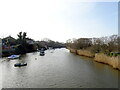
6
River Stour at Tuckton
This is a view looking east, with Tuckton Bridge in the background.
Image: © mike smith
Taken: 13 Aug 2007
0.04 miles
7

Tuckton: the end of Riverside Lane
Beyond the rear car park of the Riverside pub, public footpath number I18 extends beyond the black car and leads down to the river.
See Image for the next photo along the footpath, with links to further photos on the path.
Image: © Chris Downer
Taken: 24 Sep 2016
0.04 miles
9
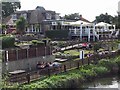
The Riverside at Tuckton
This pub/restaurant is right beside the River Stour, and is very popular, especially during warm summer weekends. It was a Brewer's Fayre establishment, but changed ownership in 2007 to the Mitchells & Butlers Group.
Image: © mike smith
Taken: 13 Aug 2007
0.05 miles
10
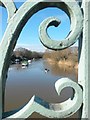
Tuckton: a kayaker on the Stour
Looking upstream along the Stour through the bright, ornate ironwork of Tuckton Bridge as a man kayaks towards us down the centre of the river.
Image: © Chris Downer
Taken: 17 Feb 2018
0.05 miles