IMAGES TAKEN NEAR TO
Pembroke Road, BOURNEMOUTH, BH4 8HE
Introduction
This page details the photographs taken nearby to Pembroke Road, BH4 8HE by members of the Geograph project.
The Geograph project started in 2005 with the aim of publishing, organising and preserving representative images for every square kilometre of Great Britain, Ireland and the Isle of Man.

There are currently over 7.5m images from over14,400 individuals and you can help contribute to the project by visiting https://www.geograph.org.uk
Image Map
Images are licensed for reuse under creativecommons.org/licenses/by-sa/2.0
Notes
- Clicking on the map will re-center to the selected point.
- The higher the marker number, the further away the image location is from the centre of the postcode.
Image Listing (63 Images Found)
Images are licensed for reuse under creativecommons.org/licenses/by-sa/2.0
Image
Details
Distance
1
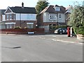
Westbourne: postbox № BH4 180, Westbourne Park Road
A George V-reign postbox on the corner of Herbert and Westbourne Park Roads.
Image: © Chris Downer
Taken: 20 Sep 2008
0.04 miles
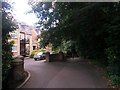
2
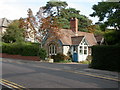
Westbourne, lodge
On Alumhurst Road, a lodge for Nightingale House, a mental health unit. The lodge has a sign "Bridges Nursery"; for growing plants, as a therapy.
Image: © Mike Faherty
Taken: 22 Sep 2009
0.06 miles
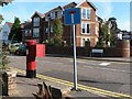
3

Westbourne: postbox № BH4 17, Alumhurst Road
A Victorian postbox on the corner of Warren Road.
Image: © Chris Downer
Taken: 20 Sep 2008
0.10 miles
4
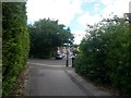
Westbourne: western end of footpath A01
This public footpath descends out of Alum Chine and emerges here at Warren Road (ahead) and Drury Road (left).
See Image for the view down the path from across the road, and Image for the next view down the path behind us, and links to further photos on the route.
Image: © Chris Downer
Taken: 14 Jul 2016
0.10 miles
5
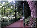
Westbourne: footpath A01 from Warren Road
Looking along this footpath which descends into the wooded idyll of Alum Chine from the end of Warren Road, with Drury Road off to the right.
See Image for the next view along the path, and links to further photos on the route.
Image: © Chris Downer
Taken: 14 Jul 2016
0.10 miles
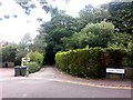
6
Westbourne: flats accessed off footpath A01
This public footpath leads into Alum Chine from Warren Road, and the first short stretch incorporates driveway access to the modern looking block of apartments on the left.
See Image for the next view along the path ahead, with links to further pictures on the route, and Image for the view behind us onto Warren Road.
Image: © Chris Downer
Taken: 14 Jul 2016
0.13 miles
7
Westbourne: postbox № BH4 127, Rosemount Road
Looking along the first bit of Rosemount Road, a short cul-de-sac which ends abruptly with a turning circle.
Image: © Chris Downer
Taken: 20 Sep 2008
0.13 miles
8

Rozel Manor, apartment block, Western Road
Image: © David Smith
Taken: 30 Mar 2017
0.14 miles
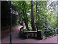
9
Westbourne: footpath A01 enters Alum Chine
This public footpath leads from Warren Road into Alum Chine - here, we see it just after a small bend as it enters the wooded chine itself.
See Image for a view up the path from the bottom, and Image for the next view on the path behind us.
Image: © Chris Downer
Taken: 14 Jul 2016
0.14 miles
10
Westbourne: footpath A01 to Warren Road
This footpath climbs the side of Alum Chine (at a gentle gradient, as we are already well above the floor of the chine) towards Warren Road. We stand at its eastern end, where it joins the various paths through the chine, which are not designated as public rights of way but are freely usable as they are on public land anyway.
See Image for the view towards us down the path, and links to further pictures along the route.
Image: © Chris Downer
Taken: 14 Jul 2016
0.15 miles