IMAGES TAKEN NEAR TO
The Oaks, VERWOOD, BH31 6YL
Introduction
This page details the photographs taken nearby to The Oaks, BH31 6YL by members of the Geograph project.
The Geograph project started in 2005 with the aim of publishing, organising and preserving representative images for every square kilometre of Great Britain, Ireland and the Isle of Man.

There are currently over 7.5m images from over14,400 individuals and you can help contribute to the project by visiting https://www.geograph.org.uk
Image Map
Images are licensed for reuse under creativecommons.org/licenses/by-sa/2.0
Notes
- Clicking on the map will re-center to the selected point.
- The higher the marker number, the further away the image location is from the centre of the postcode.
Image Listing (27 Images Found)
Images are licensed for reuse under creativecommons.org/licenses/by-sa/2.0
Image
Details
Distance
1
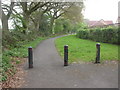
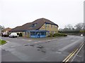
Verwood, Eastworth Road
When roads to the East & North of Verwood were remodelled, Eastworth Road (formerly linking Station & Edmondsham Roads) was truncated; the middle section became a footpath. To the left, open countryside; to the right, housing in closes.
Image: © Mike Faherty
Taken: 18 Apr 2009
0.04 miles
5
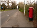
Verwood: postbox № BH31 29, Station Road
This large postbox is emptied finally at 4pm on weekdays and at 7:30am on Saturdays.
Image: © Chris Downer
Taken: 29 Mar 2009
0.11 miles
6
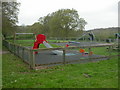
Eastworth Play Area
On Eastworth Road, owned by East Dorset District Council, & managed by Verwood Town Council. On the edge of housing development in Eastworth Road, overlooking countryside.
Image: © Mike Faherty
Taken: 18 Apr 2009
0.16 miles
7
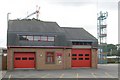
Verwood Fire Station
Verwood Fire Station, Station Road, Verwood, Dorset.
Image: © Kevin Hale
Taken: 27 Sep 2006
0.16 miles
8
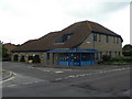
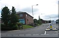
Verwood: police station
A modern building in this bit of town that has seen much recent redevelopment.
Image: © Chris Downer
Taken: 7 Sep 2008
0.20 miles
9
Verwood Police Station
On Station Road, at the corner of Jenner Close: http://www.dorset.police.uk/default.aspx?page=2505#verwood
Image: © Mike Faherty
Taken: 7 Mar 2013
0.20 miles
10
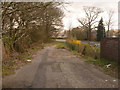
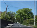
Verwood: old course of Station Road
Looking along from the old railway bridge, on the north side of the Albion Inn, on the course of Station Road before it was re-routed to the south side of the pub. The old white lines are still evident, probably 20 years after the route was closed. The ends of the brick parapets of the bridge can be seen on the edges of the picture.
Image: © Chris Downer
Taken: 29 Mar 2009
0.22 miles