IMAGES TAKEN NEAR TO
Vicarage Road, VERWOOD, BH31 6DR
Introduction
This page details the photographs taken nearby to Vicarage Road, BH31 6DR by members of the Geograph project.
The Geograph project started in 2005 with the aim of publishing, organising and preserving representative images for every square kilometre of Great Britain, Ireland and the Isle of Man.

There are currently over 7.5m images from over14,400 individuals and you can help contribute to the project by visiting https://www.geograph.org.uk
Image Map
Images are licensed for reuse under creativecommons.org/licenses/by-sa/2.0
Notes
- Clicking on the map will re-center to the selected point.
- The higher the marker number, the further away the image location is from the centre of the postcode.
Image Listing (39 Images Found)
Images are licensed for reuse under creativecommons.org/licenses/by-sa/2.0
Image
Details
Distance
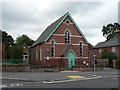
2
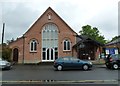
Verwood: Town Council offices
The chamber and offices of Verwood Town Council, on Vicarage Road and alongside the Methodist Church.
Image: © Chris Downer
Taken: 29 Mar 2009
0.05 miles
3
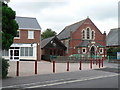
Verwood: United Reformed Church
A small church on Manor Road, in the town centre.
Image: © Chris Downer
Taken: 7 Sep 2008
0.05 miles
4
Verwood: Spar
The Spar on Manor Way, which has been pedestrianised in recent years – see Image
Image: © Chris Downer
Taken: 7 Sep 2008
0.06 miles
5
Verwood: library
The Verwood branch of Dorset County Libraries, right in the centre of town.
Image: © Chris Downer
Taken: 7 Sep 2008
0.06 miles
6
Verwood: twin towns signpost
This looks like a useful tool for the misguided motorist, but in fact it wouldn't help him very much. The finial is like an old Dorset fingerpost top, which has location and grid reference on it, but this one says VERWOOD, THREE LEGGED CROSS, TWINNING – and the signs point toward their twin towns of Liederbach, 485 miles to the left, and Champtoceaux, 246 miles to the right.
See Image and Image for close-ups of the signpost and Image for the nearest example of the type of sign which it mimics.
Image: © Chris Downer
Taken: 7 Sep 2008
0.07 miles
7
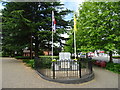
War Memorial in Verwood
Modern memorial on Ferret Green.
Image: © John M
Taken: 20 Jun 2018
0.07 miles
8
The centre of Verwood
An open space at the centre of the village, with a war memorial behind the railings
Image: © David Smith
Taken: 3 May 2014
0.08 miles
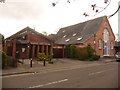
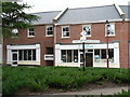
9
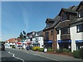
Businesses in the centre of Verwood
Buildings of different eras used for a variety of businesses
Image: © David Smith
Taken: 3 May 2014
0.08 miles
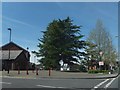
10
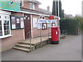
Verwood: post office and postbox № BH31 200
Verwood's post office is close to the main crossroads. The postbox is an Elizabeth II-reign, double-aperture box and it is emptied finally at 5:30pm on weekdays and at 11:30am on Saturdays. These are the latest collections of the town's fifteen postboxes.
Image: © Chris Downer
Taken: 29 Mar 2009
0.08 miles