IMAGES TAKEN NEAR TO
Castle Hill Lane, RINGWOOD, BH24 4HF
Introduction
This page details the photographs taken nearby to Castle Hill Lane, BH24 4HF by members of the Geograph project.
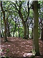
The Geograph project started in 2005 with the aim of publishing, organising and preserving representative images for every square kilometre of Great Britain, Ireland and the Isle of Man.

There are currently over 7.5m images from over14,400 individuals and you can help contribute to the project by visiting https://www.geograph.org.uk
Image Map (Loading...)


Getting Data...Please wait
Leaflet Map data © OpenStreetMap
Images are licensed for reuse under creativecommons.org/licenses/by-sa/2.0
Notes
- Clicking on the map will re-center to the selected point.
- The higher the marker number, the further away the image location is from the centre of the postcode.
Image Listing (13 Images Found)
Images are licensed for reuse under creativecommons.org/licenses/by-sa/2.0
Image
Details
Distance
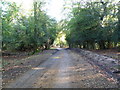
1
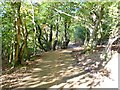
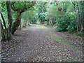
Burley, Castle Hill Lane
From near Chubb's Farm, though woodland to Castle Hill; shown on OS Explorer as traffic-free, though the lane does serve properties along its route.
Image: © Mike Faherty
Taken: 28 Oct 2011
0.09 miles
2
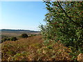
Black Bush, holly berries
Looking out across open forest towards Vales Moor; this year seems to have brought a bumper harvest of berries and nuts.
Image: © Mike Faherty
Taken: 28 Oct 2011
0.09 miles
3
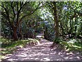
Castle Hill Lane, Burley, New Forest
Castle Hill Lane runs roughly north-south along the western edge of the privately owned land at Burley. This view is looking south as you descend from the eponymous castle (a small univallate Iron Age hillfort) towards Black Bush.
Image: © Jim Champion
Taken: 30 Jul 2006
0.12 miles
4
Burley, Coffins Holms
A belt of woodland shielding properties from the open heathland; oak, birch, with holly in the under-storey. "Holm" is the New Forest name for holly.
Image: © Mike Faherty
Taken: 28 Oct 2011
0.14 miles
5
Woodland at Coffins Holms, New Forest
Looking west from Castle Hill Lane into a wooded area on the Burley Hill ridge, intriguingly named Coffins Holms. The tree in the foreground on the right features two large birdboxes.
Image: © Jim Champion
Taken: 30 Jul 2006
0.17 miles
6
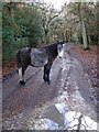
Pony on Castle Hill Lane, Burley Hill, New Forest
This gravel lane leads to Castle Hill from the southeast. There is a stables out of sight (to the right) and this pony was looking at it for a long time.
Image: © Jim Champion
Taken: 2 Dec 2006
0.17 miles
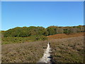
7
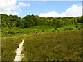
Burley Hill, New Forest
The worn path leads up from Church Moor to Castle Hill Lane north of Coffins Holms (the wooded area on top of the hill). There is an interesting series of transitions with increasing altitude - from heather, to gorse and bracken, to coniferous woodland - presumably something to do with changes in the underlying soils.
Image: © Jim Champion
Taken: 30 Jul 2006
0.19 miles
8
Footpath towards Burley
The direct route from Castle Hill.
Image: © John M
Taken: 19 Jun 2018
0.19 miles
9
Burley Hill, Castle Hill Lane
Cycle route from Pound Lane to Castle Hill. Although marked on OS as traffic-free, this is not the case.
Image: © Mike Faherty
Taken: 28 Oct 2011
0.20 miles
10
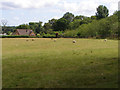
Sheep field on Burley Hill, New Forest
This field is between the woodland on Burley Hill and the road between Burley and Burley Street. The drive to Burley Hill House runs up the right hand side of the field, with the public footpath alongside.
Image: © Jim Champion
Taken: 30 Jul 2006
0.22 miles