IMAGES TAKEN NEAR TO
Maple Walk, RINGWOOD, BH24 2FT
Introduction
This page details the photographs taken nearby to Maple Walk, BH24 2FT by members of the Geograph project.
The Geograph project started in 2005 with the aim of publishing, organising and preserving representative images for every square kilometre of Great Britain, Ireland and the Isle of Man.

There are currently over 7.5m images from over14,400 individuals and you can help contribute to the project by visiting https://www.geograph.org.uk
Image Map
Images are licensed for reuse under creativecommons.org/licenses/by-sa/2.0
Notes
- Clicking on the map will re-center to the selected point.
- The higher the marker number, the further away the image location is from the centre of the postcode.
Image Listing (23 Images Found)
Images are licensed for reuse under creativecommons.org/licenses/by-sa/2.0
Image
Details
Distance
3
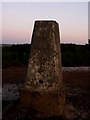
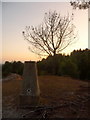
Matchams: moon over trig point
The moon is starting to become more prominent in the sky as darkness kicks in; it's getting on for ten o'clock. It is seen here directly above the trig point.
Image: © Chris Downer
Taken: 3 Jul 2009
0.13 miles
4
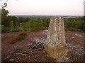
Matchams: trig point and view east
From the trig point at Avon Heath, fine views are to be had across the valley of the River Avon. There is the faint but constant noise of traffic on the A338, the main road into Bournemouth, but it is unseen below us and behind the trees.
Image: © Chris Downer
Taken: 3 Jul 2009
0.13 miles
5
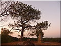
Matchams: trig point and almost overarching tree
The tree doesn't quite send its foliage over the pillar but it is not far off. We are looking roughly north, just as we approach the summit of the hill.
Image: © Chris Downer
Taken: 3 Jul 2009
0.13 miles
6
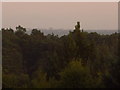
Triangulation Pillar
View of the Ordnance Survey Triangulation pillar located in Avon Heath Country Park. View towards Christchurch, and Bournemouth International Airport.
Image: © Mat Tuck
Taken: 24 Feb 2013
0.14 miles
7
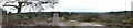
Matchams: hazy view of Bournemouth skyline
We look roughly south and can just make out the skyline of Bournemouth town centre on the horizon, about 7 miles away. The largest visible building, just left of centre, can be identified as the McCarthy & Stone building, in Image, which is situated alongside the railway station – see Image
Image: © Chris Downer
Taken: 3 Jul 2009
0.14 miles
8
Matchams: trig point, tree and roots
The roots do not belong to the pictured tree! The trig point stands particularly tall, since its foundations are not very deeply buried.
Image: © Chris Downer
Taken: 3 Jul 2009
0.14 miles
10
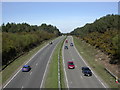
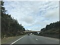
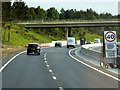
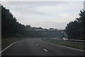
Matchams, A338
Bournemouth to Ashley Heath dual carriageway, seen from Hurn Road.
Image: © Mike Faherty
Taken: 7 Apr 2011
0.14 miles