IMAGES TAKEN NEAR TO
Waterside Close, RINGWOOD, BH24 1GW
Introduction
This page details the photographs taken nearby to Waterside Close, BH24 1GW by members of the Geograph project.
The Geograph project started in 2005 with the aim of publishing, organising and preserving representative images for every square kilometre of Great Britain, Ireland and the Isle of Man.

There are currently over 7.5m images from over14,400 individuals and you can help contribute to the project by visiting https://www.geograph.org.uk
Image Map
Images are licensed for reuse under creativecommons.org/licenses/by-sa/2.0
Notes
- Clicking on the map will re-center to the selected point.
- The higher the marker number, the further away the image location is from the centre of the postcode.
Image Listing (13 Images Found)
Images are licensed for reuse under creativecommons.org/licenses/by-sa/2.0
Image
Details
Distance
1
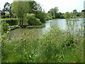
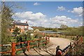
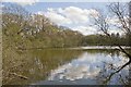
Wash Pit, Poulner
This old gravel pit is now used by local anglers.
Image: © Stuart Buchan
Taken: 12 May 2005
0.15 miles
3
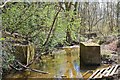
Lin Brook passes through the footings of an old bridge on its way to the River Avon at Ringwood
The brook, which has its source further to the east in Milkham Inclosure, here passes between Kingfisher Lake and Hurst Pond. The lake is probably the result of earlier gravel extraction of which this may be a remnant. Immediately to the right is a newish industrial estate, inevitably called Kingfisher Park.
Image: © Peter Facey
Taken: 11 Apr 2008
0.18 miles
4
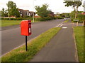
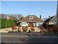
Poulner: postbox № BH24 66, North Poulner Road
A small postbox serving northern Poulner, emptied at 4pm on weekdays and at noon on Saturdays.
Image: © Chris Downer
Taken: 18 May 2009
0.20 miles
5
House named Brooklyn and lake beyond, Blashford
Seen from footpath around Kingfisher Lake. The lake here is a smaller, apparently unnamed, one just to the north of Kingfisher Lake.
Image: © Peter Facey
Taken: 11 Apr 2008
0.20 miles
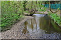
7
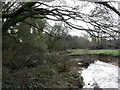
Blashford, Lin Brook
Rising in the open forest, and joining the Avon nearby; seen flowing downstream.
Image: © Mike Faherty
Taken: 12 Feb 2011
0.22 miles
8
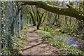
Avon Valley Path skirts Kingfisher Lake, Blashford
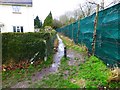
The path is sandwiched between the perimeter fence of the lake and Lin Brook. A rather annoying design because there is a bank and planting within the fence at left which provides almost no view of the lake.
Image: © Peter Facey
Taken: 11 Apr 2008
0.22 miles
9
Footpath at the end of Hurst Road
This is shown on the OS map as a Way-Marked trail - "The Avon Valley Path" one can be within 10 feet of this on Hurst Road and not see it!
Image: © David Lally
Taken: 27 Feb 2017
0.22 miles
10
Hurst Pond, Blashford
There are many ponds and lakes in this area following gravel extraction. This one is now surrounded on two sides by business parks.
Image: © Peter Facey
Taken: 11 Apr 2008
0.22 miles