IMAGES TAKEN NEAR TO
BH23 6DN
Introduction
This page details the photographs taken nearby to BH23 6DN by members of the Geograph project.
The Geograph project started in 2005 with the aim of publishing, organising and preserving representative images for every square kilometre of Great Britain, Ireland and the Isle of Man.

There are currently over 7.5m images from over14,400 individuals and you can help contribute to the project by visiting https://www.geograph.org.uk
Image Map
Images are licensed for reuse under creativecommons.org/licenses/by-sa/2.0
Notes
- Clicking on the map will re-center to the selected point.
- The higher the marker number, the further away the image location is from the centre of the postcode.
Image Listing (9 Images Found)
Images are licensed for reuse under creativecommons.org/licenses/by-sa/2.0
Image
Details
Distance
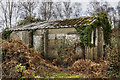
1
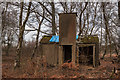
RAF Hurn - former WW2 airfield technical site (5)
Boiler house?
Image
Image: © Mike Searle
Taken: 11 Feb 2019
0.11 miles
2
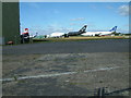
Bournemouth International Airport
Parked aircraft in the north-east sector of the airport.
Image: © Stuart Buchan
Taken: 3 Aug 2005
0.11 miles
3
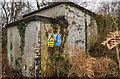
RAF Hurn - former WW2 airfield technical site (6)
-
Sleeping Shelter
Image
Image: © Mike Searle
Taken: 11 Feb 2019
0.12 miles
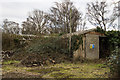
4
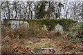
RAF Hurn - former WW2 airfield technical site (1)
-
Sleeping Shelter
In a clearing in woodland just north of the main airport industrial area are the remains of a technical site, one of several that would have served the needs of the wartime airfield. Despite the state of total dereliction, boarded up and in poor condition, the buildings are nevertheless, still recognisable as wartime structures that are probably the last to have survived unaltered (some wartime structures are known to have since been incorporated into some modern buildings).
A brief history. RAF Station Hurn airfield was planned as a satellite to RAF Ibsley, opening in 1941. It was home to a number of RAF fighter interceptor squadrons until 1944 when it was then given over to the USAAF transport command. By October 1944 it was returned briefly to the RAF before being passed into the care of the Ministry of Civil Aviation. Taking on its civil role, Hurn remained the UK's main international terminal until the opening of Heathrow in 1949. Since then Hurn has remained in use by a number of aviation operators and builders, and its modern role continues as Bournemouth International Airport.
Image
Image: © Mike Searle
Taken: 11 Feb 2019
0.13 miles
5
RAF Hurn -former WW2 airfield technical site (2)
-
Flight Offices & Crew Room
A 'T' plan building, the largest on the site.
Image
Image: © Mike Searle
Taken: 11 Feb 2019
0.13 miles
6
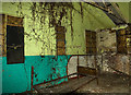
RAF Hurn - former WW2 airfield technical site (3)
-
Flight Offices & Crew Room
Interior view of an office within the 'T' shaped Flight Office building.
Image
Image: © Mike Searle
Taken: 11 Feb 2019
0.13 miles
7
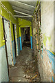
RAF Hurn - former WW2 airfield technical site (4)
-
Flight Offices & Crew Room
Interior view of the long corridor serving various offices in the T-shaped building. A long corridor with offices leading off is typical of the layout of a Flight Office.
Image
Image: © Mike Searle
Taken: 11 Feb 2019
0.13 miles
8
RAF Hurn - former WW2 airfield technical site (7)
-
Ablutions & Drying Room
START: Image
Image: © Mike Searle
Taken: 11 Feb 2019
0.14 miles
9
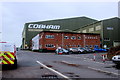
Cobham Aviation
This is the main Cobham Aviation building at Bournemouth Airport. According to their website they "deliver outsourced aviation services for military and civil customers worldwide through military training, special mission flight operations, outsourced commercial aviation and aircraft engineering."
Image: © Nigel Mykura
Taken: 6 Mar 2019
0.16 miles