IMAGES TAKEN NEAR TO
Turnberry Close, CHRISTCHURCH, BH23 1LQ
Introduction
This page details the photographs taken nearby to Turnberry Close, BH23 1LQ by members of the Geograph project.
The Geograph project started in 2005 with the aim of publishing, organising and preserving representative images for every square kilometre of Great Britain, Ireland and the Isle of Man.

There are currently over 7.5m images from over14,400 individuals and you can help contribute to the project by visiting https://www.geograph.org.uk
Image Map
Images are licensed for reuse under creativecommons.org/licenses/by-sa/2.0
Notes
- Clicking on the map will re-center to the selected point.
- The higher the marker number, the further away the image location is from the centre of the postcode.
Image Listing (41 Images Found)
Images are licensed for reuse under creativecommons.org/licenses/by-sa/2.0
Image
Details
Distance
1
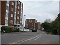
Christchurch, Fairway Drive
Apartment blocks off Stourvale Road; to the left, Sunningdale, ahead, Gleneagles.
Image: © Mike Faherty
Taken: 5 May 2010
0.01 miles
2
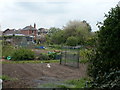
Christchurch, allotments
Douglas Avenue Allotments, with Douglas Avenue in the background.
Image: © Mike Faherty
Taken: 5 May 2010
0.05 miles
3
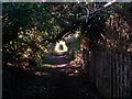
Christchurch: public footpath to the riverbank
This public footpath from Stour Road suddenly leaves behind a modern side-road alongside it and has a rural feel. It doesn't go very far - just to the riverbank with no access in either direction once there.
Image: © Chris Downer
Taken: 17 Feb 2018
0.06 miles
4
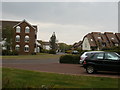
Christchurch, The Meridians
Modern housing development off Stourvale Road.
Image: © Mike Faherty
Taken: 5 May 2010
0.07 miles
5
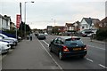
Stour Road Christchurch
Stour Rd. runs from Bargates near Christchurch Rail Station south to the river Stour which it crosses by the only bridge to Southbourne. This is the view SW from near the junction with Douglas Avenue.
Image: © Nigel Mykura
Taken: 15 Nov 2008
0.08 miles
6
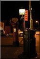
Christchurch: postbox outside Stour Road Post Office
This postbox stands outside Image, which closed down on 29 October 2008. The post office direction sign has since been painted over – see Image
Image: © Chris Downer
Taken: 28 Oct 2008
0.09 miles
7
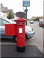
Christchurch: postbox № BH23 56, Stour Road
The object atop this postbox is a former Post Office direction sign, which was painted over in October 2008 when Stour Road Post Office closed down. For a view, albeit at night-time, a few days before that happened, see Image
Image: © Chris Downer
Taken: 4 Jul 2009
0.09 miles
8
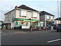
Christchurch: Stour Road Post Office
This post office is faced with the threat of closure, as with 2,500 branches in the UK during 2008 – hence the banner above the door. It is set within a Londis convenience store at nos. 108-110 Stour Road.
Image: © Chris Downer
Taken: 9 Sep 2008
0.09 miles
9
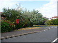
Christchurch: postbox № BH23 400, Wentworth Drive
This small postbox serves the modern housing estate, The Meridians. It is emptied finally at 5:30pm on weekdays and at 12:30pm on Saturdays.
Image: © Chris Downer
Taken: 30 Jun 2009
0.09 miles
10
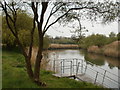
Christchurch, River Stour
Looking downstream from open land behind Image
Image: © Mike Faherty
Taken: 5 May 2010
0.12 miles