IMAGES TAKEN NEAR TO
Monkton, WIMBORNE, BH21 5NL
Introduction
This page details the photographs taken nearby to Monkton, BH21 5NL by members of the Geograph project.
The Geograph project started in 2005 with the aim of publishing, organising and preserving representative images for every square kilometre of Great Britain, Ireland and the Isle of Man.

There are currently over 7.5m images from over14,400 individuals and you can help contribute to the project by visiting https://www.geograph.org.uk
Image Map
Images are licensed for reuse under creativecommons.org/licenses/by-sa/2.0
Notes
- Clicking on the map will re-center to the selected point.
- The higher the marker number, the further away the image location is from the centre of the postcode.
Image Listing (18 Images Found)
Images are licensed for reuse under creativecommons.org/licenses/by-sa/2.0
Image
Details
Distance
1
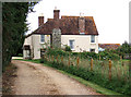
Manor Farmhouse, Monkton Up Wimborne
This is a Grade II listed rendered timber frame farmhouse, whose origins lie in the C16. Subsequently added to throughout the C17 - C19, it was apparently built on the site of, or close to an ancient chapel (according to the 1:25,000 OS map). The projecting chimney breast of flint and ashlar chequerwork is particularly attractive.
Image: © Mike Searle
Taken: 17 Sep 2010
0.02 miles
2
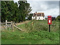
Monkton Up Wimborne: postbox № BH21 111 and Manor Farm
Manor Farm is in the background, behind the village postbox.
Image: © Chris Downer
Taken: 7 Sep 2008
0.05 miles
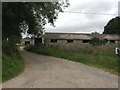
4
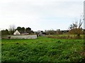
Monkton Up Wimborne, Manor Dairy
Left, farmhouse with tiled cob wall; right, farm buildings with dairy cows in the distance.
Image: © Mike Faherty
Taken: 28 Nov 2011
0.05 miles
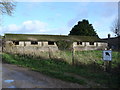
5
Monkton Up Wimborne, Manor Dairy Farm
A sign calls it "the home of St Giles Manor Herd"; part of the Shaftesbury Estate.
Image: © Mike Faherty
Taken: 12 Aug 2009
0.05 miles
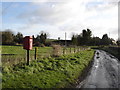
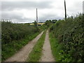
8
Bridleway, Monkton up Wimborne
The bridleway takes walkers and riders to Harley Down.
Image: © Maigheach-gheal
Taken: 4 May 2009
0.06 miles
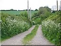
9
Monkton Up Wimborne, bridleway
Bridleway from Monkton to Tenantry Down, and then on to Gussage All Saints, Harley Gap or Wimborne St Giles.
Image: © Mike Faherty
Taken: 12 Aug 2009
0.06 miles
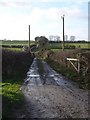
10
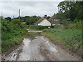
Monkton Up Wimborne: flooded road
The lane through Monkton Up Wimborne had become submerged at this point after a couple of days of heavy rain. It is not all that deep, though.
Image: © Chris Downer
Taken: 7 Sep 2008
0.07 miles