IMAGES TAKEN NEAR TO
Gaunts, WIMBORNE, BH21 4JH
Introduction
This page details the photographs taken nearby to BH21 4JH by members of the Geograph project.
The Geograph project started in 2005 with the aim of publishing, organising and preserving representative images for every square kilometre of Great Britain, Ireland and the Isle of Man.

There are currently over 7.5m images from over14,400 individuals and you can help contribute to the project by visiting https://www.geograph.org.uk
Image Map
Images are licensed for reuse under creativecommons.org/licenses/by-sa/2.0
Notes
- Clicking on the map will re-center to the selected point.
- The higher the marker number, the further away the image location is from the centre of the postcode.
Image Listing (15 Images Found)
Images are licensed for reuse under creativecommons.org/licenses/by-sa/2.0
Image
Details
Distance
1
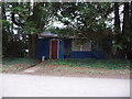
Holt: Holt Snooker Club
Not your typical image of misspent youths and smoky dives!
Image: © Chris Downer
Taken: 1 Feb 2009
0.03 miles
2
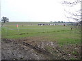
Holt: Holt United F.C.
A sneaky look through the gap in a hedge while a match is underway. Out of picture to the right is the substantial main building of the football club, including social club facilities.
Image: © Chris Downer
Taken: 15 Feb 2009
0.03 miles
3
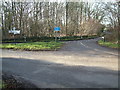
Road Junction close to Gaunt's House, Dorset
This photo was taken from the gateway to the local football club.
Image: © Stuart Buchan
Taken: 22 Jan 2006
0.04 miles
4
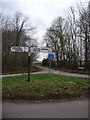
Holt: Woodcutts Lane finger post
This finger post, at the eastern end of Woodcutts Lane, retains the original Dorset finial giving location details ("Holt, Woodcutts Lane") through the centre and the six-figure grid reference below.
For a close-up of the finial, see Image
Image: © Chris Downer
Taken: 1 Feb 2009
0.05 miles
5
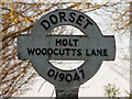
Holt: detail of Woodcutts Lane signpost
A close-up of the finial from the finger-post (see Image), giving location and grid reference details.
Image: © Chris Downer
Taken: 7 Mar 2010
0.05 miles
6

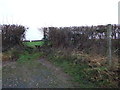
Field edge path at Gaunts
The walkable path follows these tractor tracks parallel to the edge rather than the straight route marked on the OS map.
Image: © David Martin
Taken: 25 Jun 2023
0.07 miles
7
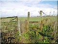
Hinton Martell, stile
At the beginning of a path from Woodcutts Lane across farmland to Gaunt's Common.
Image: © Mike Faherty
Taken: 12 Mar 2020
0.08 miles
8
Stile Near Gaunt's House
An easy stile on the footpath to Chalbury and Hinton Martell.
Image: © Lorraine and Keith Bowdler
Taken: 25 Jan 2012
0.11 miles
9
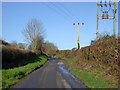
Woodcutts Lane
Heading towards Witchampton.
Image: © Robin Webster
Taken: 2 Mar 2017
0.18 miles
10
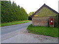
Petersham Lane, Gaunt's Common
Beside the lane in a brick pillar is a George V reign postbox, the pillar and postbox are at the entrance to Gaunts House.
Image: © Maigheach-gheal
Taken: 28 Jun 2011
0.19 miles