IMAGES TAKEN NEAR TO
Sturminster Marshall, WIMBORNE, BH21 4BX
Introduction
This page details the photographs taken nearby to BH21 4BX by members of the Geograph project.
The Geograph project started in 2005 with the aim of publishing, organising and preserving representative images for every square kilometre of Great Britain, Ireland and the Isle of Man.

There are currently over 7.5m images from over14,400 individuals and you can help contribute to the project by visiting https://www.geograph.org.uk
Image Map
Images are licensed for reuse under creativecommons.org/licenses/by-sa/2.0
Notes
- Clicking on the map will re-center to the selected point.
- The higher the marker number, the further away the image location is from the centre of the postcode.
Image Listing (80 Images Found)
Images are licensed for reuse under creativecommons.org/licenses/by-sa/2.0
Image
Details
Distance
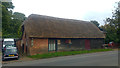
1
![White Mill and surroundings [10]](https://s2.geograph.org.uk/geophotos/07/24/80/7248026_da4f4f63_120x120.jpg)
White Mill and surroundings [10]
This house, opposite White Mill, was probably built in the 19th century. Constructed, in an 'L' shaped plan, of brick under a slate roof. Listed, for group value, grade II, with details at: https://historicengland.org.uk/listing/the-list/list-entry/1304494
White Mill is a restored 18th century mill on the banks of the River Stour at Sturminster Marshall in Dorset, some 3½ miles west of Wimborne Minster.
Image: © Michael Dibb
Taken: 28 May 2022
0.00 miles
2
![White Mill and surroundings [9]](https://s1.geograph.org.uk/geophotos/07/24/80/7248025_78482225_120x120.jpg)
White Mill and surroundings [9]
This barn opposite White Mill is probably 18th century. Timber framed and weatherboarded on a brick base, under a thatch roof. Listed, for group value, grade II, with details at: https://historicengland.org.uk/listing/the-list/list-entry/1323472
White Mill is a restored 18th century mill on the banks of the River Stour at Sturminster Marshall in Dorset, some 3½ miles west of Wimborne Minster.
Image: © Michael Dibb
Taken: 28 May 2022
0.02 miles
3
Thatched barn / workshop near White Mill, Shapwick, Dorset
Image: © Phil Champion
Taken: 8 Sep 2017
0.02 miles
5

Rabbit (Oryctolagus cuniculus), White Mill
Introduced from France in the 12th century, the rabbit was for hundreds of years protected by landowners who valued it for its meat. It became the most familiar wild animal of the British countryside and one of the most destructive agricultural pests. The burrows damage field boundaries and hedges, and disturb the surrounding soil, encouraging the growth of weeds such as nettles and ragwort.
Image: © Maigheach-gheal
Taken: 28 May 2011
0.03 miles
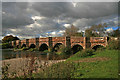
6
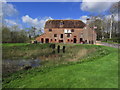
White Mill
C18 mill next to River Stour, with mill house to right. Note the millstream arches and dovecote. http://www.imagesofengland.org.uk/Details/Default.aspx?id=107317&mode=quick
Image: © Mike Faherty
Taken: 2 Jul 2011
0.03 miles
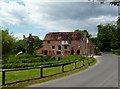
7
White Mill, Shapwick, Dorset
An 18th century corn mill on the River Stour. Now managed by the National Trust as part of their Kingston Lacy estate.
Image: © Phil Champion
Taken: 8 Sep 2017
0.03 miles
9

White Mill
See https://www.geograph.org.uk/photo/291649
Image: © JThomas
Taken: 23 Mar 2022
0.03 miles
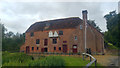
10
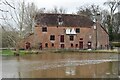
High river level at White Mill
The water level has gone down around half a metre from the previous afternoon: for a low water comparison, see Image The mill is part of the National Trust's Kingston Lacy Estate.
Image: © David Martin
Taken: 20 Feb 2024
0.03 miles