IMAGES TAKEN NEAR TO
Coombe Keynes, WAREHAM, BH20 5PP
Introduction
This page details the photographs taken nearby to BH20 5PP by members of the Geograph project.
The Geograph project started in 2005 with the aim of publishing, organising and preserving representative images for every square kilometre of Great Britain, Ireland and the Isle of Man.

There are currently over 7.5m images from over14,400 individuals and you can help contribute to the project by visiting https://www.geograph.org.uk
Image Map
Images are licensed for reuse under creativecommons.org/licenses/by-sa/2.0
Notes
- Clicking on the map will re-center to the selected point.
- The higher the marker number, the further away the image location is from the centre of the postcode.
Image Listing (30 Images Found)
Images are licensed for reuse under creativecommons.org/licenses/by-sa/2.0
Image
Details
Distance
1
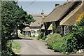
![Coombe Keynes hamlet [8]](https://s0.geograph.org.uk/geophotos/07/26/08/7260824_dadf443a_120x120.jpg)
Coombe Keynes hamlet [8]
Numbers 7 and 8 Main Street, were originally built in the 17th century and converted to two cottages in the 19th century. Constructed of rubble stone, partly roughcast, under a thatch roof. The extension on the right is of brick under a tile roof. Some windows are horizontally sliding sashes. Listed, grade II, with details at: https://historicengland.org.uk/listing/the-list/list-entry/1323337
Coombe Keynes is a hamlet, and depopulated village in Dorset, some 1½ miles south of Wool and about 5 miles southwest of Wareham. Extensive settlement remains have been found by excavation to the east of the church, indicating that once there were many more buildings. The area of earthworks, extending to some 20 acres, is a Scheduled Ancient Monument with details at: https://historicengland.org.uk/listing/the-list/list-entry/1017260
Image: © Michael Dibb
Taken: 2 Jun 2022
0.00 miles
2
![Coombe Keynes hamlet [7]](https://s0.geograph.org.uk/geophotos/07/26/08/7260820_06eefbbf_120x120.jpg)
Coombe Keynes hamlet [7]
The centre of the hamlet has this delightful small green, complete with a shady seat. Listed, grade II, with details at: https://historicengland.org.uk/listing/the-list/list-entry/1120492
Coombe Keynes is a hamlet, and depopulated village in Dorset, some 1½ miles south of Wool and about 5 miles southwest of Wareham. Extensive settlement remains have been found by excavation to the east of the church, indicating that once there were many more buildings. The area of earthworks, extending to some 20 acres, is a Scheduled Ancient Monument with details at: https://historicengland.org.uk/listing/the-list/list-entry/1017260
Image: © Michael Dibb
Taken: 2 Jun 2022
0.01 miles
4
![Coombe Keynes hamlet [6]](https://s2.geograph.org.uk/geophotos/07/26/08/7260818_0aefff55_120x120.jpg)
Coombe Keynes hamlet [6]
The curiously named Cuckoo Nod is a cottage in a terrace, probably built in the early 19th century. Constructed of rubble stone with brick dressings under a thatch roof. A single-storey extension is of brick under a tile roof. Some original internal features remain. Listed, grade II, with details at: https://historicengland.org.uk/listing/the-list/list-entry/1120492
Coombe Keynes is a hamlet, and depopulated village in Dorset, some 1½ miles south of Wool and about 5 miles southwest of Wareham. Extensive settlement remains have been found by excavation to the east of the church, indicating that once there were many more buildings. The area of earthworks, extending to some 20 acres, is a Scheduled Ancient Monument with details at: https://historicengland.org.uk/listing/the-list/list-entry/1017260
Image: © Michael Dibb
Taken: 2 Jun 2022
0.01 miles
5
![Coombe Keynes hamlet [5]](https://s3.geograph.org.uk/geophotos/07/26/08/7260815_de05cc56_120x120.jpg)
Coombe Keynes hamlet [5]
The curiously named Mini Nod is a cottage in a terrace, probably built in the early 19th century. Constructed of rubble stone with brick dressings under a thatch roof. Some original internal features remain. Listed, grade II, with details at: https://historicengland.org.uk/listing/the-list/list-entry/1305228
Coombe Keynes is a hamlet, and depopulated village in Dorset, some 1½ miles south of Wool and about 5 miles southwest of Wareham. Extensive settlement remains have been found by excavation to the east of the church, indicating that once there were many more buildings. The area of earthworks, extending to some 20 acres, is a Scheduled Ancient Monument with details at: https://historicengland.org.uk/listing/the-list/list-entry/1017260
Image: © Michael Dibb
Taken: 2 Jun 2022
0.02 miles
6
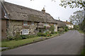
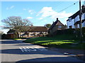
Coombe Keynes
The village has a lot of ‘picture postcard’ thatched cottages. This one is on the north side of the road leading to East Lulworth.
Image: © John Lamper
Taken: 9 May 2006
0.02 miles
7
Coombe Keynes
The village has a lot of ‘picture postcard’ thatched cottages. The road round to the right leads to the small, redundant church of the Holy Rood.
Image: © John Lamper
Taken: 9 May 2006
0.02 miles
8
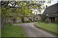
Coombe Keynes
View from permissive bridleway west towards Coombe Keynes. The Old Post Office to the right of photo
Image: © Peter Elsdon
Taken: 1 Nov 2009
0.02 miles
9
Coombe Keynes
The village is a very small but very "chocolate box picture" type of village with thatched cottages around a small village green.
Image: © Nigel Mykura
Taken: 2 Feb 2013
0.02 miles
10
![Coombe Keynes hamlet [4]](https://s1.geograph.org.uk/geophotos/07/26/08/7260813_fc3c6530_120x120.jpg)
Coombe Keynes hamlet [4]
The curiously named Odd Nod is a cottage in a terrace, probably built in the early 19th century. Constructed of rubble stone with brick dressings under a thatch roof. Some original internal features remain. Listed, grade II, with details at: https://historicengland.org.uk/listing/the-list/list-entry/1172303
Coombe Keynes is a hamlet, and depopulated village in Dorset, some 1½ miles south of Wool and about 5 miles southwest of Wareham. Extensive settlement remains have been found by excavation to the east of the church, indicating that once there were many more buildings. The area of earthworks, extending to some 20 acres, is a Scheduled Ancient Monument with details at: https://historicengland.org.uk/listing/the-list/list-entry/1017260
Image: © Michael Dibb
Taken: 2 Jun 2022
0.02 miles