IMAGES TAKEN NEAR TO
Furzebrook Road, WAREHAM, BH20 5AU
Introduction
This page details the photographs taken nearby to Furzebrook Road, BH20 5AU by members of the Geograph project.
The Geograph project started in 2005 with the aim of publishing, organising and preserving representative images for every square kilometre of Great Britain, Ireland and the Isle of Man.

There are currently over 7.5m images from over14,400 individuals and you can help contribute to the project by visiting https://www.geograph.org.uk
Image Map
Images are licensed for reuse under creativecommons.org/licenses/by-sa/2.0
Notes
- Clicking on the map will re-center to the selected point.
- The higher the marker number, the further away the image location is from the centre of the postcode.
Image Listing (20 Images Found)
Images are licensed for reuse under creativecommons.org/licenses/by-sa/2.0
Image
Details
Distance
1
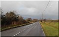
Furzebrook Road Wareham Dorset
Furzebrook Road runs from the A351 Stoborough across Furzebrook Heath towards the Purbeck Hills. A very busy road used by holiday makers staying at local camp sites and visitors to Blue Poole. There is also a constant flow of heavy goods vehicle coming and going from the local quarry works
Image: © Peter Elsdon
Taken: 14 Dec 2017
0.04 miles
2
Furzebrook Road Wareham Dorset
Dwellings alongside Furzebrook Road which runs across Stoborough Heath from Stoborough towards East Creech.
Image: © Peter Elsdon
Taken: 30 Nov 2017
0.04 miles
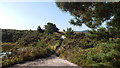
3
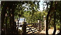
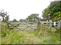
Gateway to Stoborough Heath
Public right of way from Furzebrook Road onto Stoborough Heath
Image: © Peter Elsdon
Taken: 26 Jul 2018
0.05 miles
4
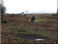
Ponies grazing on Stoborough Heath
One of the last remaining bits of Dorset heathland still remaining.
Image: © N Chadwick
Taken: 24 Oct 2006
0.09 miles
5
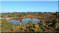
Stoborough Heath, Wareham, Dorset
The Pond on Stoborough Heath
Image: © Peter Elsdon
Taken: 21 Oct 2018
0.14 miles
6
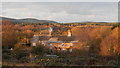
Stoborough Heath, Wareham, Dorset
Dwellings alongside Furzebrook Road. The telegraph poles show the route of the road which run across the Heath from Stoborough towards East Creech.
Image: © Peter Elsdon
Taken: 29 Apr 2016
0.15 miles
7
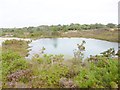
Stoborough Heath, lake
On the national nature reserve; judging from the exposed top soil, this was a former clay working. http://www.naturalengland.org.uk/ourwork/conservation/designations/nnr/1006136.aspx
Image: © Mike Faherty
Taken: 29 Aug 2014
0.15 miles
8
Stoborough Heath, gates
At the eastern boundary of the national nature reserve, with a choice of two footpaths - West, across the heath, or North, next to Furzebrook Road. http://www.naturalengland.org.uk/ourwork/conservation/designations/nnr/1006136.aspx
Image: © Mike Faherty
Taken: 29 Aug 2014
0.15 miles
9
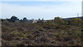
Stoborough Heath, Wareham, Dorset
Track on the west side of The Pond. Creech Barrow can be seen on the sky line to the right.
Image: © Peter Elsdon
Taken: 6 Aug 2018
0.16 miles
10

Stoborough Heath, Wareham, Dorset
Track alongside the caravan camp site on the left. Furzebrook Road at the end of the track running from Stoborough, left towards East Creech.
Image: © Peter Elsdon
Taken: 19 May 2017
0.16 miles