IMAGES TAKEN NEAR TO
Tollerford Road, POOLE, BH17 9AQ
Introduction
This page details the photographs taken nearby to Tollerford Road, BH17 9AQ by members of the Geograph project.
The Geograph project started in 2005 with the aim of publishing, organising and preserving representative images for every square kilometre of Great Britain, Ireland and the Isle of Man.

There are currently over 7.5m images from over14,400 individuals and you can help contribute to the project by visiting https://www.geograph.org.uk
Image Map
Images are licensed for reuse under creativecommons.org/licenses/by-sa/2.0
Notes
- Clicking on the map will re-center to the selected point.
- The higher the marker number, the further away the image location is from the centre of the postcode.
Image Listing (7 Images Found)
Images are licensed for reuse under creativecommons.org/licenses/by-sa/2.0
Image
Details
Distance
1

Canford Heath: postbox № BH17 219, Tollerford Road
This little postbox serves the northern extremity of the vast 70s housing estate of Canford Heath. It is emptied finally at 5:30pm on weekdays and at noon on Saturdays. Most of the roads in this part of the estate are named after Dorset locations, such as Holywell Close and Tollerford Road, the pictured roads.
Image: © Chris Downer
Taken: 27 Jul 2009
0.09 miles
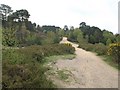
2

Paths, Canford Heath
There has been some imaginative planning of the layout of this estate, with intriguing little landscapes being created by these winding footpaths between Holywell Close and Stourpaine Road.
Image: © Derek Harper
Taken: 28 Apr 2010
0.17 miles
3

Canford Heath, Portesham Way
South-west of heathland, modern housing development off Culliford Crescent.
Image: © Mike Faherty
Taken: 18 Jun 2011
0.19 miles
4
Canford Heath, Dorset
Canford Heath lies to the north of Poole, forming a natural barrier between Poole and Wimborne Minster.
Image: © Stuart Buchan
Taken: 14 Nov 2005
0.21 miles
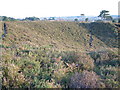
5
Canford Heath
This southwest corner of the heath, which is the fourth largest heathland in Dorset, is under considerable pressure from neighbouring housing estates. This track, here approaching a crossing with Longfleet Drive, seems to be gradually widening.
Image: © Derek Harper
Taken: 28 Apr 2010
0.23 miles
6
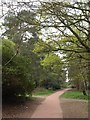
Footpath crossing, Longfleet Drive
Longfleet Drive, which further north crosses the open heathland of Canford Heath, here follows a wooded corridor down the centre of the Canford Heath housing estate, with turns on the left to Overcombe Close and right to Tollerford Road.
Image: © Derek Harper
Taken: 28 Apr 2010
0.23 miles
7

Path, Canford Heath
A path from Longfleet Drive to Tollerford Road cuts between a small patch of (mainly birch) woodland and housing on Stourpaine Road.
Image: © Derek Harper
Taken: 28 Apr 2010
0.25 miles