IMAGES TAKEN NEAR TO
Godmanston Close, POOLE, BH17 8BT
Introduction
This page details the photographs taken nearby to Godmanston Close, BH17 8BT by members of the Geograph project.
The Geograph project started in 2005 with the aim of publishing, organising and preserving representative images for every square kilometre of Great Britain, Ireland and the Isle of Man.

There are currently over 7.5m images from over14,400 individuals and you can help contribute to the project by visiting https://www.geograph.org.uk
Image Map
Images are licensed for reuse under creativecommons.org/licenses/by-sa/2.0
Notes
- Clicking on the map will re-center to the selected point.
- The higher the marker number, the further away the image location is from the centre of the postcode.
Image Listing (22 Images Found)
Images are licensed for reuse under creativecommons.org/licenses/by-sa/2.0
Image
Details
Distance
1

Haymoor Bottom
Haymoor Bottom Nature Reserve stretches South along Dorset Way, and then West beside electricity pylons; it comprises damp heath and grassland. http://www.boroughofpoole.com/facilities/ref:F465e9bc764d21/
Image: © Mike Faherty
Taken: 26 Nov 2009
0.06 miles
2
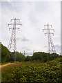
Haymoor Bottom, power lines
Striding across the nature reserve towards Lower Mannington Sub-station. http://www.boroughofpoole.com/environment/countryside/haymoor-bottom-nature-reserve/
Image: © Mike Faherty
Taken: 6 Jul 2014
0.06 miles
3
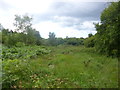
Canford Heath, Haymoor Bottom
A detached part of Canford Heath - scrub, woodland and small patches of heathland: http://www.boroughofpoole.com/environment/countryside/haymoor-bottom-nature-reserve/
Image: © Mike Faherty
Taken: 6 Jul 2014
0.07 miles
4
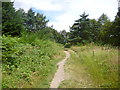
Haymoor Bottom, path
Heading through the nature reserve towards Chalbury Close: http://www.boroughofpoole.com/environment/countryside/haymoor-bottom-nature-reserve/
Image: © Mike Faherty
Taken: 6 Jul 2014
0.07 miles
5
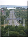
Canford Heath: looking along Canford Way
Looking along this straight stretch of the A3049 – essentially a by-pass allowing through traffic to avoid the town centre – from the slopes of Canford Heath to the north.
Image: © Chris Downer
Taken: 9 Jul 2009
0.09 miles
6

Canford Heath, Sherborn Crescent
Sherborn Crescent (presumably with a deliberately archaic spelling of Sherborne without a final "e") curves North-east from Adastral Road to Canford Heath Road; smaller roads, mostly cul-de-sacs, radiate from it, all named after Dorset villages.
Image: © Mike Faherty
Taken: 26 Nov 2009
0.10 miles
7
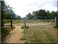
Haymoor Bottom, gateway
Entrance to the nature reserve from Seatown Close: http://www.boroughofpoole.com/environment/countryside/haymoor-bottom-nature-reserve/
Image: © Mike Faherty
Taken: 6 Jul 2014
0.10 miles
8
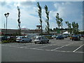
Tesco Extra, Tower Park, Poole
Part of a shopping/entertainment complex on the outskirts of Poole, Dorset.
Image: © Stuart Buchan
Taken: 19 Jul 2005
0.10 miles
9

Canford Heath, footpath
Footpath from Canford Heath Road across Image to Alderney and Tower Park.
Image: © Mike Faherty
Taken: 26 Nov 2009
0.11 miles
10
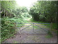
Haymoor Bottom, gate
Near the southern end of the nature reserve, heading through woodland towards open heathland. http://www.boroughofpoole.com/environment/countryside/haymoor-bottom-nature-reserve/
Image: © Mike Faherty
Taken: 6 Jul 2014
0.12 miles