IMAGES TAKEN NEAR TO
Admiralty Park, Station Road, POOLE, BH16 6HX
Introduction
This page details the photographs taken nearby to Admiralty Park, Station Road, BH16 6HX by members of the Geograph project.
The Geograph project started in 2005 with the aim of publishing, organising and preserving representative images for every square kilometre of Great Britain, Ireland and the Isle of Man.

There are currently over 7.5m images from over14,400 individuals and you can help contribute to the project by visiting https://www.geograph.org.uk
Image Map (Loading...)


Getting Data...Please wait
Leaflet Map data © OpenStreetMap
Images are licensed for reuse under creativecommons.org/licenses/by-sa/2.0
Notes
- Clicking on the map will re-center to the selected point.
- The higher the marker number, the further away the image location is from the centre of the postcode.
Image Listing (20 Images Found)
Images are licensed for reuse under creativecommons.org/licenses/by-sa/2.0
Image
Details
Distance
1

Holton Heath Industrial Estate
The expanding Holton Heath Industrial Estate has a wide variety of business enterprises within it. Shown here is a unit where classic cars are restored to concours standard. The Weymouth-London Waterloo railway line passes through the square and there is a small unmanned station nearby. Holton Heath itself is a Site of Special Scientific Interest managed by English Nature.
Image: © John Lamper
Taken: 10 Apr 2004
0.05 miles
2
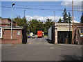
Admiralty Business Park
At one time the whole of this complex was given over to the production of ammunition and ordnance.
I somehow don't think I would have got away with taking pictures in those days.
Image: © Anthony Vosper
Taken: 22 Aug 2014
0.08 miles
3
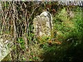
Old Boundary Marker by footpath at Holton Heath Station
Estate Boundary Marker by the footpath, in parish of Wareham St Martin (Purbeck District), Station Road, 50m S gate no 2 overlooking ditch.
Surveyed
Milestone Society National ID: DO_SAND02em.
Image: © Milestone Society
Taken: Unknown
0.10 miles
4
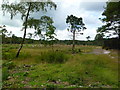
Sandford Heath NNR
In this piece of the National Nature Reserve, off Station Road, conifers have been cleared, to allow heathland regeneration. http://www.english-nature.org.uk/citation/citation_photo/2000234.pdf
Image: © Mike Faherty
Taken: 6 Aug 2011
0.12 miles
5
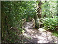
Holton Heath, footbridge
Across a drainage ditch on the footpath to Sandford.
Image: © Mike Faherty
Taken: 6 Aug 2011
0.12 miles
6
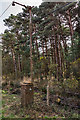
RNCF Holton Heath: vintage street light (1)
-
The history of the former Royal Naval Cordite Factory at Holton Heath has been well documented, spanning both of the world wars of the 20th century. The facility opened in 1916, and was in continuous operation producing cordite for the Royal Navy until 1945, the site then being placed on a care and maintenance basis. Some parts continued to be used by the Admiralty, but these too eventually closed in 1997 when the whole site was developed thereafter as an industrial estate, with many of the old buildings retained.
The cast-iron lamp post in the photo is one of two at this location, being very early forms of industrial electric street lighting. Their manufacture was by the contractors Mann Egerton & Co. Ltd., and were made by Davey Paxman & Co. Ltd in 1916, the same year that the RNCF facility was opened.
Image
Image: © Mike Searle
Taken: 5 Apr 2018
0.13 miles
7
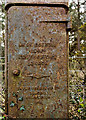
RNCF Holton Heath: vintage street light (2)
-
A close-up of the *base inscription that gives details of the contractors Mann Egerton of London, and the makers Davey Paxman & Co. Ltd of Colchester; both companies are still trading today. Mann Egerton are now a brand of car dealers across East Anglia, whilst Davey Paxman are more well known for their diesel generators under the Paxman brand, although due to various acquisitions, are now owned by the German company MAN SE.
* 'Mann Egerton & Co. Ltd Contractors London - Davey Paxman & Co. Ltd Makers Colchester 1916'.
Image: © Mike Searle
Taken: 5 Apr 2018
0.13 miles
8
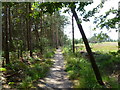
Holton Heath, footpath
Across wood- and heathland from Holton Heath to Sandford. The path is known as "Roman Road"; an archaeological investigation is shortly to investigate whether its origin is such.
Image: © Mike Faherty
Taken: 6 Aug 2011
0.17 miles
9
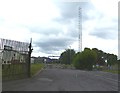
Holton Heath, telecoms mast
Next to Holton Heath Station, operated by Network Rail. In the background, part of Admiralty Park Trading Estate.
Image: © Mike Faherty
Taken: 6 Aug 2011
0.20 miles
10
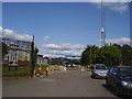
Road closed
Blocks of stone on the road adjacent to the station serve to prevent the road being used as a'rat run' to the nearby industrial estate.
Image: © Anthony Vosper
Taken: 22 Aug 2014
0.20 miles