IMAGES TAKEN NEAR TO
Beacon Park Road, POOLE, BH16 5PE
Introduction
This page details the photographs taken nearby to Beacon Park Road, BH16 5PE by members of the Geograph project.
The Geograph project started in 2005 with the aim of publishing, organising and preserving representative images for every square kilometre of Great Britain, Ireland and the Isle of Man.

There are currently over 7.5m images from over14,400 individuals and you can help contribute to the project by visiting https://www.geograph.org.uk
Image Map
Images are licensed for reuse under creativecommons.org/licenses/by-sa/2.0
Notes
- Clicking on the map will re-center to the selected point.
- The higher the marker number, the further away the image location is from the centre of the postcode.
Image Listing (29 Images Found)
Images are licensed for reuse under creativecommons.org/licenses/by-sa/2.0
Image
Details
Distance
1
Upton: postbox № BH16 274, Blandford Road North
An Elizabeth II-reign postbox facing the main Blandford Road and backing onto St. David's Road; there is no access from one to the other at this point. The box is emptied finally at 5:30pm on weekdays and at 12:15pm on Saturdays.
Image: © Chris Downer
Taken: 15 Nov 2009
0.07 miles
2
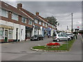
Upton, shopping parade
At the junction of Dorchester and Moorland Roads; visible premises are town council building, undertakers, hair & beauty, estate agents, off-licence and veterinary centre; around the corner & out of sight, newsagent, hardware and fish and chips.
Image: © Mike Faherty
Taken: 1 Oct 2009
0.11 miles
3
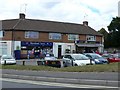
Shops
This small group of shops is on the corner of the Dorchester Rd and Moorland Way
Image: © Nigel Mykura
Taken: 29 Jul 2010
0.11 miles
4
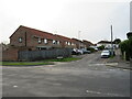
Moorland Way, Upton, near Poole
Moorland Way is a minor road in Upton, near Poole.
Image: © Malc McDonald
Taken: 6 Feb 2022
0.11 miles
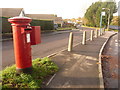
5
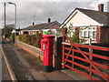
Upton: postbox № BH16 282, Beacon Park Road
This Elizabeth II-reign postbox is emptied finally at 5:30pm on weekdays and at 10:45am on Saturdays.
Image: © Chris Downer
Taken: 15 Nov 2009
0.13 miles
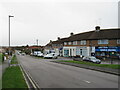
6
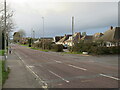
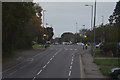
Dorchester Road, Upton
Dorchester Road would once have been a trunk road, taking traffic through the village of Upton. A by-pass now enables through traffic to avoid the village.
Image: © Malc McDonald
Taken: 6 Feb 2022
0.17 miles
7
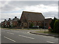
Upton Methodist Church
At the junction of Dorchester and Sea View Roads; an inscription in the gable reads "Wesleyan Chapel 1865". http://www.uptonmethodistchurch.net/
Image: © Mike Faherty
Taken: 1 Oct 2009
0.17 miles
8
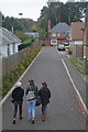
Upton : Oxborrow Close
Looking along Oxborrow Close off of Dorchester Road.
Image: © Lewis Clarke
Taken: 28 Oct 2017
0.17 miles
9
Pinewood Road, Upton, near Poole
Pinewood Road is a residential road in Upton, near Poole.
Image: © Malc McDonald
Taken: 6 Feb 2022
0.17 miles
10
Upton : Dorchester Road B3067
Looking along Dorchester Road as it heads through Upton.
Image: © Lewis Clarke
Taken: 28 Oct 2017
0.18 miles