IMAGES TAKEN NEAR TO
Palmerston Road, BOURNEMOUTH, BH1 4FD
Introduction
This page details the photographs taken nearby to Palmerston Road, BH1 4FD by members of the Geograph project.
The Geograph project started in 2005 with the aim of publishing, organising and preserving representative images for every square kilometre of Great Britain, Ireland and the Isle of Man.

There are currently over 7.5m images from over14,400 individuals and you can help contribute to the project by visiting https://www.geograph.org.uk
Image Map
Images are licensed for reuse under creativecommons.org/licenses/by-sa/2.0
Notes
- Clicking on the map will re-center to the selected point.
- The higher the marker number, the further away the image location is from the centre of the postcode.
Image Listing (251 Images Found)
Images are licensed for reuse under creativecommons.org/licenses/by-sa/2.0
Image
Details
Distance
1
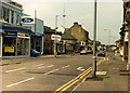
Boscombe: a little bit of then & now - what was the top of Haviland Rd West in 2013
Haviland Road West at this end is no more, a short section of service road has replaced it leading to the side of the O2 Academy behind the camera position (formerly the Bournemouth Opera House, and historically, Boscombe Hippodrome). The view in front is of the Aldi Supermarket built on the site of the Hendy Ford garage. A view for comparison purposes with that taken in c.1988:
Image
Image: © Mike Searle
Taken: 5 Mar 2013
0.01 miles
2
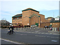
The Royal Arcade, Boscombe
This entrance is much less ornate than the main entrance, seen in Image
Image: © David Smith
Taken: 29 Mar 2017
0.01 miles
3
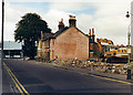
Boscombe: a little bit of then & now - top of Haviland Rd West c.1988 (5)
Site clearance in operation preparatory to the Boscombe Sovereign Centre development, a key component of the controversial Boscombe Plan of the late 1980s. The view is of Haviland Road West near its junction with Palmerston Road. The old Hendy Ford/Hendy Lennox garage in Palmerston Road is on the left.
The same view today: Image]
NEXT: Image
Image: © Mike Searle
Taken: Unknown
0.01 miles
4
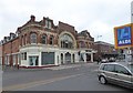
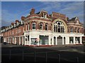
Royal Arcade, Boscombe
The Royal Arcade shopping arcade in Boscombe, near Bournemouth. It dates from the 1890s and is Grade II listed. More information can be found on the British Listed Buildings website: https://britishlistedbuildings.co.uk/101152825-royal-arcade-ward
Image: © Malc McDonald
Taken: 17 Aug 2021
0.01 miles
5
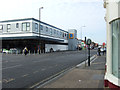
Boscombe: a little bit of then & now - Palmerston Rd c.1988 (2)
Palmerston Road despite being on the western periphery of the area scheduled in the Boscombe Plan for redevelopment during the late 1980s, nevertheless did not escape the developers entirely. The Hendy-Ford garage on the left has since been demolished and is now occupied by an Aldi supermarket, whilst further along on the same side where Craze Bros. garage and other premises used to be, there is now a car park, and BP petrol station. The same view today: Image
NEXT: Image
Image: © Mike Searle
Taken: Unknown
0.02 miles
6
Boscombe: a little bit of then & now - view from Palmerston Rd in 2013
A view for comparison purposes with that taken in c.1988. The pedestrians are crossing Palmerston Road where its former junction with Haviland Road West used to be - now gone. Image]
Image: © Mike Searle
Taken: 5 Mar 2013
0.02 miles
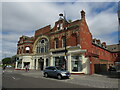
7
Boscombe: Royal Arcade west entrance
The western entrance of this Victorian shopping arcade, on Palmerston Road.
Image: © Chris Downer
Taken: 13 Jul 2008
0.02 miles
9
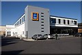
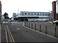
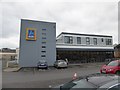
Aldi, Boscombe
This gleaming new store which, from this direction, might be anything were it not for the shopping trolleys, is also shown in Image
Image: © Derek Harper
Taken: 10 Mar 2010
0.02 miles
10
Boscombe: a little bit of then & now - Palmerston Rd in 2013
An Aldi supermarket now occupies the site of the Hendy-Ford garage, whilst next door further along is a BP petrol station. A view for comparison purposes with that taken in c.1988. Image]
Image: © Mike Searle
Taken: 5 Mar 2013
0.02 miles