IMAGES TAKEN NEAR TO
Branksome Wood Road, POOLE, BH12 1HR
Introduction
This page details the photographs taken nearby to Branksome Wood Road, BH12 1HR by members of the Geograph project.
The Geograph project started in 2005 with the aim of publishing, organising and preserving representative images for every square kilometre of Great Britain, Ireland and the Isle of Man.

There are currently over 7.5m images from over14,400 individuals and you can help contribute to the project by visiting https://www.geograph.org.uk
Image Map
Images are licensed for reuse under creativecommons.org/licenses/by-sa/2.0
Notes
- Clicking on the map will re-center to the selected point.
- The higher the marker number, the further away the image location is from the centre of the postcode.
Image Listing (92 Images Found)
Images are licensed for reuse under creativecommons.org/licenses/by-sa/2.0
Image
Details
Distance
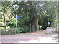
1

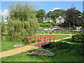
Bournemouth Gardens: Branksome Wood Road crossing
Branksome Wood Road crosses the Gardens at this point, a few yards west of the borough boundary and hence within the borough of Poole.
Upstream of the bridge, this is properly Coy Pond Gardens – the Poole section.
Image: © Chris Downer
Taken: 12 Jan 2008
0.01 miles
2
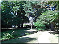
Bourne Valley Greenway, near Bournemouth
The Bourne Valley Greenway entering Bournemouth's Upper Gardens.
The road in the foreground marks the boundary between the boroughs of Bournemouth and Poole.
Image: © Malc McDonald
Taken: 25 Aug 2021
0.02 miles
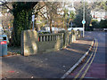
3
Branksome Wood Road Bridge
Bourne Stream at the Branksome Wood Road Bridge
Image: © Shaun Ferguson
Taken: 14 Apr 2008
0.02 miles
4
Poole, Brunstead Road bridge
1930s bridge over the Bourne Stream; to the left, Upper Gardens in Poole, Image, on the other side of the bridge, out of sight, Upper Gardens in Bournemouth Image, at a different time of year.
Image: © Mike Faherty
Taken: 9 Jan 2009
0.02 miles
5
Poole Upper Gardens, Bourne Stream
As seen from roadbridge on Brunstead Road Image, which forms the boundary between Bournemouth & Poole. For information about the gardens, see http://boroughofpoole.com/facilities/ref:F465e9bc752c16/
Image: © Mike Faherty
Taken: 9 Jan 2009
0.02 miles
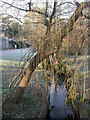
6
Bridge over The Bourne, near Bournemouth
A wooden bridge carrying a footpath over The Bourne in Coy Pond Gardens, near Bournemouth.
Image: © Malc McDonald
Taken: 25 Aug 2021
0.03 miles
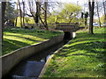
8

Bournemouth Gardens: concrete channel
Right on the boundary of the boroughs of Bournemouth and Poole, the Bourne Stream is led through this brief concrete channel, with about 1½ miles to go before it reaches the sea at Bournemouth pier. The bridge in the background is Image
Image: © Chris Downer
Taken: 12 Jan 2008
0.03 miles
9
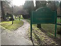
Bournemouth Gardens: borough boundary
Having just crossed Branksome Wood Road, we almost immediately cross the boundary from Poole into Bournemouth. This sign welcomes us to the latter.
Image: © Chris Downer
Taken: 12 Jan 2008
0.04 miles
10
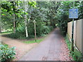
Bourne Valley Greenway, near Bournemouth
A view of the Bourne Valley Greenway passing through Bournemouth's Upper Gardens.
Image: © Malc McDonald
Taken: 25 Aug 2021
0.05 miles