IMAGES TAKEN NEAR TO
Venning Avenue, BOURNEMOUTH, BH11 9QG
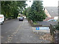
Introduction
This page details the photographs taken nearby to Venning Avenue, BH11 9QG by members of the Geograph project.
The Geograph project started in 2005 with the aim of publishing, organising and preserving representative images for every square kilometre of Great Britain, Ireland and the Isle of Man.

There are currently over 7.5m images from over14,400 individuals and you can help contribute to the project by visiting https://www.geograph.org.uk
Image Map (Loading...)


Getting Data...Please wait
Leaflet Map data © OpenStreetMap
Images are licensed for reuse under creativecommons.org/licenses/by-sa/2.0
Notes
- Clicking on the map will re-center to the selected point.
- The higher the marker number, the further away the image location is from the centre of the postcode.
Image Listing (25 Images Found)
Images are licensed for reuse under creativecommons.org/licenses/by-sa/2.0
Image
Details
Distance
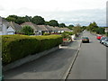
1
Bungalow Land
These bungalows are on Dalewood Avenue.
Image: © mike smith
Taken: 20 Jun 2007
0.08 miles
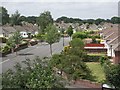
2
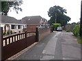
Bearwood, Weldon Avenue
The strip of land between the Poole boundary, Magna and Ringwood Roads has 1930s bungalow-lined roads, such as Weldon Avenue.
Image: © Mike Faherty
Taken: 24 Aug 2009
0.11 miles
3
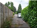
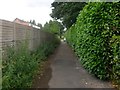
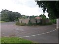
West Howe: railings across footpath U14
Looking along this public footpath formed by the northern segment of High Howe Lane. It is not navigable by car as a through route but has access towards us to a few houses, plus one or possibly two behind us.
See Image for the next view along the course of the path ahead, and Image for the next view behind us - each with links to further photos along the route.
Image: © Chris Downer
Taken: 17 Jul 2016
0.11 miles
4
West Howe: 106 High Howe Lane
Looking along the northern segment of High Howe Lane - this segment is a dead end behind us, leading only to a few houses, but it forms public footpath U14 to Ringwood Road.
See Image for the next view along the road ahead, and Image for the next behind us - each with links to further pictures along the route.
Image: © Chris Downer
Taken: 17 Jul 2016
0.11 miles
5
West Howe: last few houses in High Howe Lane
Looking along the northern segment of High Howe Lane - this segment is a dead end just ahead, leading only to these houses, but it forms public footpath U14 which continues to Ringwood Road.
See Image for the view towards us from beyond the railings ahead, and Image for the next behind us - each with links to further pictures along the route.
Image: © Chris Downer
Taken: 17 Jul 2016
0.11 miles
6
West Howe: the non-motorable part of footpath U14
Looking along this public footpath formed by the northern segment of High Howe Lane. It is not navigable by car as a through route but has access to a few houses from the far end, plus one or possibly two behind us.
See Image for the next view along the course of the path ahead, and Image for the next view behind us - each with links to further photos along the route.
Image: © Chris Downer
Taken: 17 Jul 2016
0.11 miles
7
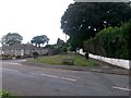
West Howe: this segment of High Howe Lane is footpath U14
The main carriageway in the picture is Knighton Heath Road (right) and Shapland Avenue (left), while High Howe Lane runs behind and ahead of us forming a staggered junction.
The segment of High Howe Lane ahead is a dead end leading only to a few houses, but it forms public footpath U14 continuing to Ringwood Road. The course of the footpath at this end is the pavement ahead, and not the main carriageway veering off the straight.
See Image for the next view along the course of the footpath, with links to further pictures along the route.
Image: © Chris Downer
Taken: 17 Jul 2016
0.11 miles
8
West Howe: footpath U14 approaches Shapland Avenue
Looking along the northern segment of High Howe Lane as it reaches Shapland Avenue/Knighton Heath Road - see Image for the opposite view and more details.
This segment of High Howe Lane is a dead end behind us, leading only to a few houses, but it forms public footpath U14 to Ringwood Road.
See Image for the next view along the path behind us, with links to further pictures along the route.
Image: © Chris Downer
Taken: 17 Jul 2016
0.11 miles
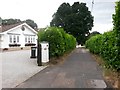
9
Bearwood, Spicer Lane
Westwards from the Poole boundary (which is probably at this road name sign), Spicer Lane continues as a road for about 100m, then as a bridleway into square SZ0496.
Image: © Mike Faherty
Taken: 24 Aug 2009
0.12 miles
10
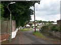
West Howe: footpath U14 from Ringwood Road
The main A348 Ringwood Road runs just alongside us, out of shot to the left. Parallel to it is a service road, left, which swings almost back on itself to become High Howe Lane. This northern segment of High Howe Lane is public footpath U14 - it forms a short access driveway here, then becomes a non-motorable path, and then opens out into another part of the lane.
See Image for the next view along the public footpath, with links to further photos along the route.
Image: © Chris Downer
Taken: 17 Jul 2016
0.12 miles