IMAGES TAKEN NEAR TO
Gaydon Rise, BOURNEMOUTH, BH11 9PR
Introduction
This page details the photographs taken nearby to Gaydon Rise, BH11 9PR by members of the Geograph project.
The Geograph project started in 2005 with the aim of publishing, organising and preserving representative images for every square kilometre of Great Britain, Ireland and the Isle of Man.

There are currently over 7.5m images from over14,400 individuals and you can help contribute to the project by visiting https://www.geograph.org.uk
Image Map (Loading...)


Getting Data...Please wait
Leaflet Map data © OpenStreetMap
Images are licensed for reuse under creativecommons.org/licenses/by-sa/2.0
Notes
- Clicking on the map will re-center to the selected point.
- The higher the marker number, the further away the image location is from the centre of the postcode.
Image Listing (61 Images Found)
Images are licensed for reuse under creativecommons.org/licenses/by-sa/2.0
Image
Details
Distance
1
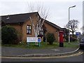
West Howe: postbox № BH11 207, High Oaks Gardens
High Oaks Gardens, a relatively recent development, has had this postbox since shortly after West Howe Post Office closed, just up the road, in March 2004 (see Image).
Image: © Chris Downer
Taken: 4 Jan 2009
0.02 miles
2
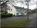
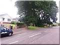
West Howe, Shoulder of Mutton
Built on what is a now a service road to the parallel Ringwood Road, the Shoulder of Mutton is one of Bournemouth's oldest pubs, dating from days when West Howe was farm, wood or heathland. Listed in the 2009 Good Beer Guide, the pub feels very much a local. Porch, with to left stone-flagged public bar, and to right T-shaped lounge with beamed ceiling. Cask ales on offer at my visit: Dorset Piddle Santa's Potty, Ringwood Fortyniner. For some customer reviews, see http://www.beerintheevening.com/pubs/comments.shtml/2889/
Image: © Mike Faherty
Taken: 8 Dec 2008
0.04 miles
3
West Howe: Deepdene Lane from Ringwood Road
Looking down Deepdene Lane, which forms public footpath U42, as it heads down from Ringwood Road - actually the service road; the main dual carriageway is behind us.
See Image for the view towards us from just ahead, with links to further photos along the lane.
Image: © Chris Downer
Taken: 17 Jul 2016
0.06 miles
4
West Howe: looking down Deepdene Lane
Deepdene Lane is a minor no-through road which also forms public footpath U42 to Ringwood Road, just behind us. See Image for the view up the lane from near the bottom, and Image for the next view on behind us - each with links to further photos along the route.
Image: © Chris Downer
Taken: 17 Jul 2016
0.06 miles
5
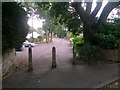
West Howe: footpath U42 arrives on Ringwood Road
This is the top of Deepdene Lane, forming public footpath U42, as it comes out onto Ringwood Road - actually the service road; the main dual carriageway is just behind the trees ahead.
See Image for the view behind us, with links to further photos along the route, and Image for the view down the lane from ahead.
Image: © Chris Downer
Taken: 17 Jul 2016
0.06 miles
6
West Howe: looking up Deepdene Lane
Deepdene Lane is a minor no-through road which also forms public footpath U42 to Ringwood Road, just through the gap at the top. The course of the public right behind us diverges from the road slightly.
See Image for the view behind us from the top of the lane, and Image for the next view on the lane behind us - each with links to further photos along the route.
Image: © Chris Downer
Taken: 17 Jul 2016
0.07 miles
7
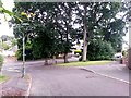
West Howe: footpath U42 joins Deepdene Lane
Deepdene Lane, whose junction with Knighton Heath Road is to the right, is a minor no-through road which also forms public footpath U42 to Ringwood Road. The course of the public right of way includes this path heading behind us, probably the original route of the lane before the junction was reconfigured with modern-day traffic in mind.
See Image for the view behind us from just ahead, and Image for the next view on the lane ahead - each with links to further photos along the route.
Image: © Chris Downer
Taken: 17 Jul 2016
0.07 miles
8
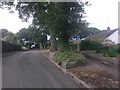
West Howe: Deepdene Lane arrives on Knighton Heath Road
Deepdene Lane, whose junction with Knighton Heath Road is just ahead, is a minor no-through road which also forms public footpath U42 to Ringwood Road behind us. The course of the public right of way includes this path ahead of us to the right, probably the original route of the lane before the junction was reconfigured with modern-day traffic in mind.
See Image for the view up the footpath from the bottom, and Image for the next view up the lane from just ahead, with links to further photos along the route.
Image: © Chris Downer
Taken: 17 Jul 2016
0.09 miles
9
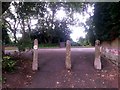
West Howe: the start of footpath U42
This public footpath is formed by Deepdene Lane, whose junction is in the distance. However, the course of the public right of way includes this path ahead of us, probably the original route of the lane before the junction was reconfigured with modern-day traffic in mind.
See Image for the next view on the footpath, and links to further photos along the route.
Image: © Chris Downer
Taken: 17 Jul 2016
0.09 miles
10
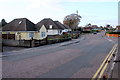
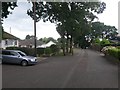
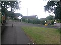
Bungalows on High Howe Lane
This area of suburban Bournemouth has many houses like these. These ones are close to the junction of High Howe Lane and Meadow View Rd and Knighton Heath Rd.
Image: © Nigel Mykura
Taken: 25 Nov 2018
0.11 miles