IMAGES TAKEN NEAR TO
Ringwood Road, BOURNEMOUTH, BH11 9LF
Introduction
This page details the photographs taken nearby to Ringwood Road, BH11 9LF by members of the Geograph project.
The Geograph project started in 2005 with the aim of publishing, organising and preserving representative images for every square kilometre of Great Britain, Ireland and the Isle of Man.

There are currently over 7.5m images from over14,400 individuals and you can help contribute to the project by visiting https://www.geograph.org.uk
Image Map
Images are licensed for reuse under creativecommons.org/licenses/by-sa/2.0
Notes
- Clicking on the map will re-center to the selected point.
- The higher the marker number, the further away the image location is from the centre of the postcode.
Image Listing (86 Images Found)
Images are licensed for reuse under creativecommons.org/licenses/by-sa/2.0
Image
Details
Distance
1
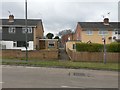
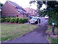
Bear Cross: footpath E06 to Marpet Close
Looking from the central reservation of Ringwood Road, we look along a short public footpath to Marpet Close, a short cul-de-sac which serves as a rear driveway access and has no addresses on it.
See Image for the view towards us from along the path, with links to a couple of other photos along the path.
Image: © Chris Downer
Taken: 18 Mar 2017
0.01 miles
2
Bear Cross: footpath E06 to Ringwood Road
Looking along this short public footpath from Marpet Close onto the main Ringwood Road.
The house number, 1094, above the garage refers to Ringwood Road; there are no properties addressed Marpet Close.
See Image for the view behind us onto Marpet Close, and Image for the view towards us from the road ahead.
Image: © Chris Downer
Taken: 26 Jun 2016
0.01 miles
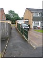
3
Bear Cross: approaching footpath E06 in Marpet Close
Reaching the dead end of Image, we see the opening of the public footpath, just the other side of the low dark fence. The extent of the public right of way appears to come through the gap and include the few metres heading towards us to the pavement.
See Image for the view towards us from just along the path, with links to a couple more pictures along the route.
Image: © Chris Downer
Taken: 26 Jun 2016
0.01 miles
4
Bear Cross: footpath E06 arrives at Marpet Close
This short public footpath from Ringwood Road arrives on Marpet Close at its dead end. Marpet Close does not have any houses with addresses on it, so it essentially acts as a rear driveway for the surrounding houses.
See Image for the view behind us along the path, and Image for the view towards us from the road ahead.
Image: © Chris Downer
Taken: 18 Mar 2017
0.01 miles
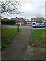
5
Bear Cross: footpath E05 to Anchor Close
A very short public footpath - just 13 metres in length - linking the main Ringwood Road with the adjacent dead end of Anchor Close.
The sign on the reverse of the bollard is for a shared foot/cycle path, referring to the pavement of Ringwood Road, where we are standing. The sign on this side denotes that cyclists should dismount on the path ahead.
See Image for the view towards us from ahead.
Image: © Chris Downer
Taken: 28 Jun 2016
0.03 miles
6
Bear Cross: footpath E05 is very short
This public footpath is a mere 13 metres in length, heading onto the main Ringwood Road from the dead end of Anchor Road, just at our feet.
See Image for the view towards us form ahead, and Image for a wider view from behind us.
Image: © Chris Downer
Taken: 18 Mar 2017
0.03 miles
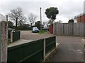
7
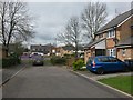
Bear Cross: the dead end of Anchor Close
The end of Anchor Close does a little right-angled turn just behind us, to head back toward the main Ringwood Road without quite meeting it. To far left, a little public footpath does meet Ringwood Road, which we see in the background.
See Image for a closer view of the footpath.
Image: © Chris Downer
Taken: 18 Mar 2017
0.03 miles
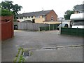
8
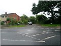
Bear Cross: Marpet Close
A small cul-de-sac off Magna Road, unusual in that it does not contain any addresses - it is purely an access to rear garages of these few properties in Magna Road and around the corner in Ringwood Road.
Image: © Chris Downer
Taken: 26 Jun 2016
0.03 miles
9
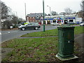
Bear Cross, control box
Next to Bear Cross Roundabout, an iron control box inscribed "Bournemouth Corporation Tramways", and maker's name "Britannia Engineers Colchester"; part of the infrastructure of the trolleybus route from Moordown to Bear Cross. Trolleybuses disappeared in Bournemouth in 1969. http://www.bournemouth-buses.co.uk/bmth_corporation.html
Image: © Mike Faherty
Taken: 21 Jan 2010
0.03 miles
