IMAGES TAKEN NEAR TO
Holloway Avenue, BOURNEMOUTH, BH11 9JR
Introduction
This page details the photographs taken nearby to Holloway Avenue, BH11 9JR by members of the Geograph project.
The Geograph project started in 2005 with the aim of publishing, organising and preserving representative images for every square kilometre of Great Britain, Ireland and the Isle of Man.

There are currently over 7.5m images from over14,400 individuals and you can help contribute to the project by visiting https://www.geograph.org.uk
Image Map (Loading...)


Getting Data...Please wait
Leaflet Map data © OpenStreetMap
Images are licensed for reuse under creativecommons.org/licenses/by-sa/2.0
Notes
- Clicking on the map will re-center to the selected point.
- The higher the marker number, the further away the image location is from the centre of the postcode.
Image Listing (72 Images Found)
Images are licensed for reuse under creativecommons.org/licenses/by-sa/2.0
Image
Details
Distance
1

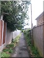
West Howe: footpath E19 emerges onto Zamek Close
A public footpath from Anstey Road enters Image at its dead end.
See Image for a view towards us from the road ahead, and Image for the next view on the path behind us.
Image: © Chris Downer
Taken: 9 Jul 2012
0.04 miles
2

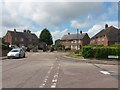
West Howe: Zamek Close
This curiously named street is typical of the vast West Howe council housing estate - indeed, probably typical of many large council estates across the country.
Dozens of West Howe roads are named after people, being recognisable surnames - Moore Avenue, Maclean Road, Draper Road, Cunningham Crescent, Verney Road. Only one, though, hints at the fact that they are named after First World War personnel - that being Pilot Hight Road which has the occupational prefix included.
I presume that Zamek is likewise a soldier or pilot's surname.
Image: © Chris Downer
Taken: 9 Jul 2012
0.04 miles
3
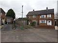
West Howe: the dead end of Zamek Close
A view of the turning circle of Image, with Deacon Road on the right.
Right at the head of the dead end, we can see public footpath E19 emerging from between the two pairs of semi-detached houses.
See Image] for a closer view of the footpath, with links to further photos on the route.
Image: © Chris Downer
Taken: 10 Jul 2016
0.04 miles
4
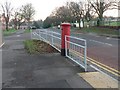
West Howe: postbox № BH11 241, Holloway Avenue
An Elizabeth II-reign box, to which the railings have given way, by the junction with Youngs Road.
Image: © Chris Downer
Taken: 7 Dec 2008
0.05 miles
5
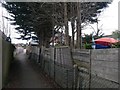
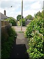
West Howe: footpath E19 from Zamek Close
Looking from Image along this public footpath to Anstey Road. See Image for the view onto the road from along the path, and links to a couple of other photos along the route.
Image: © Chris Downer
Taken: 18 Mar 2017
0.06 miles
6
West Howe: footpath E19 is slightly off-straight
Looking along this public footpath from Anstey Road from about halfway along, as the destination on Zamek Close becomes visible ahead.
See Image for the arrival on Anstey Road behind us, and Image for the emergence onto Zamek Close ahead.
Image: © Chris Downer
Taken: 18 Mar 2017
0.06 miles
7
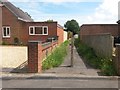
West Howe: midway along footpath E16
We are halfway along this public footpath from Deacon Road to Woodfield Road.
See Image for the path's emergence onto Woodfield Road, and Image for the Deacon Road end behind us.
Image: © Chris Downer
Taken: 10 Jul 2016
0.07 miles
8
West Howe: footpaths E15 and E16 arrive on Woodfield Road
A wasp flies past as we looking along the end of public footpath E15 from Youngs Road, onto Woodfield Road. Footpath E16 from Deacon Road arrives directly opposite.
See Image for the view towards us from just along path E16; and Image for the view behind us from just about here.
Image: © Chris Downer
Taken: 10 Jul 2016
0.07 miles
9
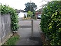
West Howe: footpath E16 from Deacon Road
The public footpath ahead leads to Woodfield Road, and further paths continue the more or less straight course to Youngs Road and Poole Lane.
See Image for the next view of the path ahead, and further views all along the route to Poole Lane.
Image: © Chris Downer
Taken: 10 Jul 2016
0.07 miles
10
West Howe: footpath E16 reaches Woodfield Road
The opposite view to Image - we look from the end of public footpath E16, towards public footpath E15 arriving across the road.
See Image for the view along the path behind us.
Image: © Chris Downer
Taken: 10 Jul 2016
0.07 miles