IMAGES TAKEN NEAR TO
Youngs Road, BOURNEMOUTH, BH11 9EW
Introduction
This page details the photographs taken nearby to Youngs Road, BH11 9EW by members of the Geograph project.
The Geograph project started in 2005 with the aim of publishing, organising and preserving representative images for every square kilometre of Great Britain, Ireland and the Isle of Man.

There are currently over 7.5m images from over14,400 individuals and you can help contribute to the project by visiting https://www.geograph.org.uk
Image Map (Loading...)


Getting Data...Please wait
Leaflet Map data © OpenStreetMap
Images are licensed for reuse under creativecommons.org/licenses/by-sa/2.0
Notes
- Clicking on the map will re-center to the selected point.
- The higher the marker number, the further away the image location is from the centre of the postcode.
Image Listing (64 Images Found)
Images are licensed for reuse under creativecommons.org/licenses/by-sa/2.0
Image
Details
Distance
1
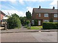
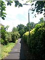
West Howe: footpath E10 from Youngs Road
Looking across Youngs Road along this public footpath to Mayfair Gardens and Poole Lane.
See Image for the next view ahead, and Image for a view towards us from ahead, showing another footpath leading behind us just to our left.
Image: © Chris Downer
Taken: 10 Jul 2016
0.04 miles
2
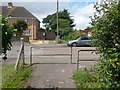
West Howe: footpaths E10 and E15 come out on Youngs Road
Looking across Youngs Road from the emergence of public footpath E10 from Poole Lane, while another path, footpath E15, comes out almost directly opposite us from Woodfield Road.
See Image for the view down E10 from just ahead of us, and Image for the next view on path E15.
Image: © Chris Downer
Taken: 10 Jul 2016
0.05 miles
3
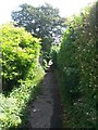
West Howe: footpath E10 heads for Youngs Road
Looking along this path from alongside Mayfair Gardens. The path existed before Mayfair Gardens was built - see Image for more discussion and the view towards us from ahead.
See Image for the next view along the path.
Image: © Chris Downer
Taken: 10 Jul 2016
0.05 miles
4
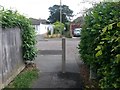
West Howe: footpath E15 nears Youngs Road
This short public footpath approaches Youngs Road ahead, beyond which another footpath starts almost directly opposite - footpath E10 to Poole Lane.
See Image for a view up this path from the start of E10, and links to further pictures on the way to Poole Lane; and Image for the next view on the path behind us.
Image: © Chris Downer
Taken: 10 Jul 2016
0.05 miles
5
West Howe: lamppost on footpath E10
This public footpath heads towards Mayfair Gardens and, eventually, Poole Lane from Youngs Road, behind us.
See Image for the next view along the path ahead, and Image for the next view behind us.
Image: © Chris Downer
Taken: 10 Jul 2016
0.05 miles
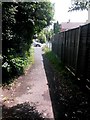
6
West Howe: quite rural looking on footpath E15
Two thick hedges give a deceptively rural feel to a stretch of this short public footpath between Woodfield and Youngs Roads.
See Image for the next (less rural looking) view along the path ahead, and Image for a view behind us from just here.
Image: © Chris Downer
Taken: 10 Jul 2016
0.06 miles
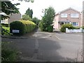
7
West Howe: footpath E10 comes out on Mayfair Gardens
This public footpath from Youngs Road existed before Mayfair Gardens was built, and its course extends across the road here, to the pavement which is offset from the road ahead.
See Image for the view up from Poole Lane, at the bottom of the hill, and Image for the view up this way from just in front of us.
Image: © Chris Downer
Taken: 10 Jul 2016
0.06 miles
8
West Howe: footpath E16 reaches Woodfield Road
The opposite view to Image - we look from the end of public footpath E16, towards public footpath E15 arriving across the road.
See Image for the view along the path behind us.
Image: © Chris Downer
Taken: 10 Jul 2016
0.07 miles
9
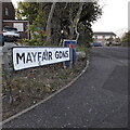
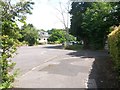
West Howe: Mayfair Gardens
A short cul-de-sac which splays left and right at the top of the hill in the background, dating from the 1970s. Its left-hand pavement also forms the start of a public footpath through to Youngs Road behind. (See Image for a picture from the middle of the carriageway, and more discussion and photos of the public right of way.)
The sign is the standard Bournemouth nameplate from the 1980s, affixed with tubular steel which protrudes at each side.
This is photo no.264 of a series of 453 in my coronavirus lockdown walking project:
See https://www.geograph.org.uk/article/My-2020-Coronavirus-Lockdown-walking-project for the complete set of photos.
Image: © Chris Downer
Taken: 16 Apr 2020
0.07 miles
10
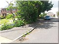
West Howe: Mayfair Gardens and footpath E10
Looking along the southwest pavement of Image, which veers from the carriageway of the road and forms a public footpath to Youngs Road - the footpath existed before the road was built.
See Image for the next view along the route of the footpath, with further links to photos all along the route to Youngs Road and beyond.
Image: © Chris Downer
Taken: 10 Jul 2016
0.07 miles