IMAGES TAKEN NEAR TO
Deacon Gardens, BOURNEMOUTH, BH11 9ED
Introduction
This page details the photographs taken nearby to Deacon Gardens, BH11 9ED by members of the Geograph project.
The Geograph project started in 2005 with the aim of publishing, organising and preserving representative images for every square kilometre of Great Britain, Ireland and the Isle of Man.

There are currently over 7.5m images from over14,400 individuals and you can help contribute to the project by visiting https://www.geograph.org.uk
Image Map (Loading...)


Getting Data...Please wait
Leaflet Map data © OpenStreetMap
Images are licensed for reuse under creativecommons.org/licenses/by-sa/2.0
Notes
- Clicking on the map will re-center to the selected point.
- The higher the marker number, the further away the image location is from the centre of the postcode.
Image Listing (86 Images Found)
Images are licensed for reuse under creativecommons.org/licenses/by-sa/2.0
Image
Details
Distance
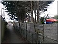
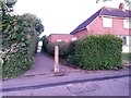
1
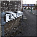
West Howe: Deacon Gardens
A small cul-de-sac in the 1950s West Howe council estate, but relatively unusual development from the 80s. The vast majority of the housing in the estate is either original 50s or much more recent infill.
The sign is of a simple design which was produced in great numbers, I believe at the back end of the 1980s, and quite a few remain. The white is beginning to peel on many, revealing the silver colour of the metal, but this one is in good condition.
This is photo no.103 of a series of 453 in my coronavirus lockdown walking project:
See https://www.geograph.org.uk/article/My-2020-Coronavirus-Lockdown-walking-project for the complete set of photos.
Image: © Chris Downer
Taken: 16 Apr 2020
0.02 miles
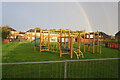
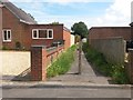
2

West Howe: playpark behind Anstey Road
Hidden behind housing on all four sides and accessed by a path either from Anstey Road or Deacon Gardens, this small playpark is similar to several in the large West Howe council housing estate.
Image: © Chris Downer
Taken: 9 Jul 2012
0.04 miles
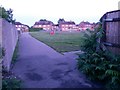
3
Turf Zone "BournePlay"
At Deacons Road Park, Bear Cross.
Image: © Ian S
Taken: 15 Nov 2022
0.04 miles
4
West Howe: footpath E17 comes out at a playpark
The end of Image, as it arrives at this small open space with a playpark in its centre - Image
See Image] for a view back along the path from a short distance ahead.
Image: © Chris Downer
Taken: 28 Jun 2016
0.05 miles
5
West Howe: footpath E19 from Zamek Close
Looking from Image along this public footpath to Anstey Road. See Image for the view onto the road from along the path, and links to a couple of other photos along the route.
Image: © Chris Downer
Taken: 18 Mar 2017
0.06 miles
6
West Howe: footpath E19 is slightly off-straight
Looking along this public footpath from Anstey Road from about halfway along, as the destination on Zamek Close becomes visible ahead.
See Image for the arrival on Anstey Road behind us, and Image for the emergence onto Zamek Close ahead.
Image: © Chris Downer
Taken: 18 Mar 2017
0.06 miles
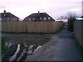
7
West Howe: footpath E16 from Deacon Road
The public footpath ahead leads to Woodfield Road, and further paths continue the more or less straight course to Youngs Road and Poole Lane.
See Image for the next view of the path ahead, and further views all along the route to Poole Lane.
Image: © Chris Downer
Taken: 10 Jul 2016
0.06 miles
8
West Howe: footpath E17 to Anstey Road
Looking across the corner of the playpark (Image]) and along the public footpath to Anstey Road. The extent of the public right of way is from level with the back garden walls.
See Image] for the reciprocal view onto the park from just down the path, and Image] for the view along the path from the far end.
Image: © Chris Downer
Taken: 6 Jan 2018
0.06 miles
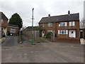
9
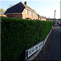
West Howe: Deacon Road
Looking southwest from Creasey Road as the evening sunlight shines on these typical 1950s council houses. The first building is a semi-detached pair while there is a terrace of four in the background.
The sign is the standard Bournemouth nameplate from the 1980s, affixed with tubular steel which protrudes at each side.
This is photo no.104 of a series of 453 in my coronavirus lockdown walking project:
See https://www.geograph.org.uk/article/My-2020-Coronavirus-Lockdown-walking-project for the complete set of photos.
Image: © Chris Downer
Taken: 16 Apr 2020
0.06 miles
10
West Howe: footpath E17 from Anstey Road
A short public footpath leading to a small open space with play-park - see Image for its emergence at the park.
Image: © Chris Downer
Taken: 28 Jun 2016
0.06 miles