IMAGES TAKEN NEAR TO
Turnbull Lane, BOURNEMOUTH, BH11 9BG
Introduction
This page details the photographs taken nearby to Turnbull Lane, BH11 9BG by members of the Geograph project.
The Geograph project started in 2005 with the aim of publishing, organising and preserving representative images for every square kilometre of Great Britain, Ireland and the Isle of Man.

There are currently over 7.5m images from over14,400 individuals and you can help contribute to the project by visiting https://www.geograph.org.uk
Image Map
Images are licensed for reuse under creativecommons.org/licenses/by-sa/2.0
Notes
- Clicking on the map will re-center to the selected point.
- The higher the marker number, the further away the image location is from the centre of the postcode.
Image Listing (55 Images Found)
Images are licensed for reuse under creativecommons.org/licenses/by-sa/2.0
Image
Details
Distance
1
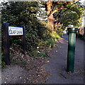
Bear Cross: Leaf Lane
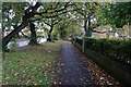
A path linking Duck Lane with Poole Lane, running through the playing field near the latter but seen here from the Duck Lane end. Many of the footpaths on the West Howe estate and thereabouts have been given names in the last couple of years, a safety initiative whose intention is that, in the event of calling for help, one's location can be more easily described. I am pretty sure that the path has been named only since that time.
The sign is a modern one, dating from around 2014-15, by which time the council had replaced the coloured logo, which had been prone to fading after a while, to simple wording BOURNEMOUTH BOROUGH COUNCIL in smaller type.
This is photo no.238 of a series of 453 in my coronavirus lockdown walking project:
See https://www.geograph.org.uk/article/My-2020-Coronavirus-Lockdown-walking-project for the complete set of photos.
Image: © Chris Downer
Taken: 16 Apr 2020
0.06 miles
2
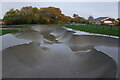
Turf Zone "HalfpipeTurf"
Skate park off Hollow Avenue, West Howe.
Image: © Ian S
Taken: 15 Nov 2022
0.08 miles
3
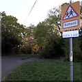
Bear Cross: Duck Lane
A road around the periphery of the West Howe housing estate that manages to retain a rural feel. It contains a couple of blocks of council flats at the other end, opposite the entrance to Oak Academy, the local secondary school.
The road sign is a mini version of the standard one from around 2005, such as at Image, but the top half of the sign is blank, rather than containing the logo. As this sign would face the sun only in the morning, I doubt that it has faded when the rest of the sign is fine!
This is photo no.116 of a series of 453 in my coronavirus lockdown walking project:
See https://www.geograph.org.uk/article/My-2020-Coronavirus-Lockdown-walking-project for the complete set of photos.
Image: © Chris Downer
Taken: 16 Apr 2020
0.10 miles
4
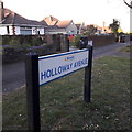
Bear Cross: Holloway Avenue
Holloway Avenue forms a main route at the western side of the large West Howe 1950s council estate and then continues to the main Ringwood Road outside of the estate, hence the bungalows - patently not council housing - that we see here opposite the end of Duck Lane.
The sign is a modern one, from 2010-15 when this more modern, abstract emblem rather than the traditional town coat of arms as the working logo of the council.
This is photo no.202 of a series of 453 in my coronavirus lockdown walking project:
See https://www.geograph.org.uk/article/My-2020-Coronavirus-Lockdown-walking-project for the complete set of photos.
Image: © Chris Downer
Taken: 16 Apr 2020
0.11 miles
5
Turf Zone "WestHowe"
On Duck Lane, West Howe.
Image: © Ian S
Taken: 15 Nov 2022
0.14 miles
6
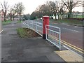
West Howe: postbox № BH11 241, Holloway Avenue
An Elizabeth II-reign box, to which the railings have given way, by the junction with Youngs Road.
Image: © Chris Downer
Taken: 7 Dec 2008
0.15 miles
7
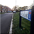
Bear Cross: Leaf Gardens
Leaf Gardens is a cul-de-sac on a small development dating from the early 2000s, on part of Butcher's Coppice, the remainder of which remains a Scout campsite.
The sign is a modern one, dating from around 2014-15, by which time the council had replaced the coloured logo, which had been prone to fading after a while, to simple wording BOURNEMOUTH BOROUGH COUNCIL in smaller type.
This is photo no.237 of a series of 453 in my coronavirus lockdown walking project:
See https://www.geograph.org.uk/article/My-2020-Coronavirus-Lockdown-walking-project for the complete set of photos.
Image: © Chris Downer
Taken: 16 Apr 2020
0.16 miles
8
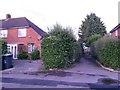
West Howe: footpath E19 arrives on Anstey Road
This public footpath from the dead end of Zamek Close reaches its destination, with the turning of Milford Drive opposite.
See Image for the view towards us from the pavement ahead, and Image for the next view on the path behind us.
Image: © Chris Downer
Taken: 18 Mar 2017
0.16 miles
9
West Howe: footpath E19 to Zamek Close
This public footpath leads to the dead end of Zamek Close.
See Image for the view towards us from just along the path, with links to further photos on the route.
Image: © Chris Downer
Taken: 28 Jun 2016
0.17 miles
10
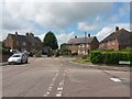
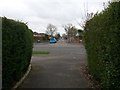
West Howe: the dead end of Zamek Close
A view of the turning circle of Image, with Deacon Road on the right.
Right at the head of the dead end, we can see public footpath E19 emerging from between the two pairs of semi-detached houses.
See Image] for a closer view of the footpath, with links to further photos on the route.
Image: © Chris Downer
Taken: 10 Jul 2016
0.17 miles