IMAGES TAKEN NEAR TO
Wimborne Road, BOURNEMOUTH, BH11 9BE
Introduction
This page details the photographs taken nearby to Wimborne Road, BH11 9BE by members of the Geograph project.
The Geograph project started in 2005 with the aim of publishing, organising and preserving representative images for every square kilometre of Great Britain, Ireland and the Isle of Man.

There are currently over 7.5m images from over14,400 individuals and you can help contribute to the project by visiting https://www.geograph.org.uk
Image Map
Images are licensed for reuse under creativecommons.org/licenses/by-sa/2.0
Notes
- Clicking on the map will re-center to the selected point.
- The higher the marker number, the further away the image location is from the centre of the postcode.
Image Listing (103 Images Found)
Images are licensed for reuse under creativecommons.org/licenses/by-sa/2.0
Image
Details
Distance
1
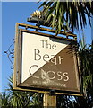
Turf Zone "Wimborne"
On Wimborne Road, Bear Cross.
Image: © Ian S
Taken: 15 Nov 2022
0.03 miles
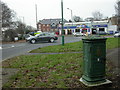
2
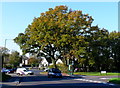
Bear Cross
This has been an important junction for hundreds of years. It is where the A341 Wimborne Road crosses the A348 Ringwood Road. Its name comes from Beare and before that Bearu meaning wooded.
Image: © Nigel Mykura
Taken: 15 Nov 2011
0.04 miles

4
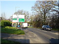
Wimborne Road (A341) approaching roundabout
Image: © JThomas
Taken: 24 Mar 2022
0.04 miles
5
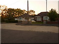
Bear Cross: Bournemouth?s highest house numbers
Wimborne Road, which starts a good few miles southwest in the town centre, approaches its end at Bear Cross Roundabout. Set back from the main carriageway via a parallel service road, the last row of bungalows ends with these two, numbers 1821 and 1823. On the other side, the even numbers reach only 1716.
Image: © Chris Downer
Taken: 19 May 2010
0.05 miles
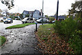
7
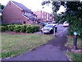
Bear Cross: footpath E05 to Anchor Close
A very short public footpath - just 13 metres in length - linking the main Ringwood Road with the adjacent dead end of Anchor Close.
The sign on the reverse of the bollard is for a shared foot/cycle path, referring to the pavement of Ringwood Road, where we are standing. The sign on this side denotes that cyclists should dismount on the path ahead.
See Image for the view towards us from ahead.
Image: © Chris Downer
Taken: 28 Jun 2016
0.05 miles
8
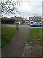
Bear Cross: footpath E05 is very short
This public footpath is a mere 13 metres in length, heading onto the main Ringwood Road from the dead end of Anchor Road, just at our feet.
See Image for the view towards us form ahead, and Image for a wider view from behind us.
Image: © Chris Downer
Taken: 18 Mar 2017
0.05 miles
9
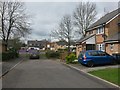
Bear Cross: the dead end of Anchor Close
The end of Anchor Close does a little right-angled turn just behind us, to head back toward the main Ringwood Road without quite meeting it. To far left, a little public footpath does meet Ringwood Road, which we see in the background.
See Image for a closer view of the footpath.
Image: © Chris Downer
Taken: 18 Mar 2017
0.05 miles
10
Bear Cross, control box
Next to Bear Cross Roundabout, an iron control box inscribed "Bournemouth Corporation Tramways", and maker's name "Britannia Engineers Colchester"; part of the infrastructure of the trolleybus route from Moordown to Bear Cross. Trolleybuses disappeared in Bournemouth in 1969. http://www.bournemouth-buses.co.uk/bmth_corporation.html
Image: © Mike Faherty
Taken: 21 Jan 2010
0.05 miles