IMAGES TAKEN NEAR TO
Wallisdown Road, BOURNEMOUTH, BH11 8PN
Introduction
This page details the photographs taken nearby to Wallisdown Road, BH11 8PN by members of the Geograph project.
The Geograph project started in 2005 with the aim of publishing, organising and preserving representative images for every square kilometre of Great Britain, Ireland and the Isle of Man.

There are currently over 7.5m images from over14,400 individuals and you can help contribute to the project by visiting https://www.geograph.org.uk
Image Map
Images are licensed for reuse under creativecommons.org/licenses/by-sa/2.0
Notes
- Clicking on the map will re-center to the selected point.
- The higher the marker number, the further away the image location is from the centre of the postcode.
Image Listing (67 Images Found)
Images are licensed for reuse under creativecommons.org/licenses/by-sa/2.0
Image
Details
Distance
1
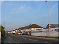
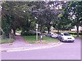
Wallisdown: the boundary swaps sides
Wallisdown Road is two miles long and dead straight apart from one small bend, and throughout its length it is the boundary of Bournemouth and Poole boroughs. At the crossroads pictured, for some reason having hugged the frontages of properties on the south side, it crosses the road and then hugs the northern frontages for the remainder of the road (behind camera). This means that Poole maintains the road itself from this point westwards, while Bournemouth maintains it into the distance.
This is demonstrated by the white, Poole lamppost in the foreground with more distant lampposts being Bournemouth's green. (Also, there is a Poole litter bin outside the row of shops shown here, and a Bournemouth bin outside the shops opposite.)
However, all the even numbered properties (left) in Wallisdown Road are in Bournemouth, while odds are in Poole.
Image: © Chris Downer
Taken: 8 Jun 2008
0.02 miles
3
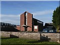
Wallisdown: former Methodist church
According to a sale board on the edge of the premises, the site is under offer. It is likely that more flats will eventually occupy the site.
Image: © Chris Downer
Taken: 12 Jan 2008
0.03 miles
4

Wallisdown: Little Hen?s Nursery
The Image has found new use as an early education setting and, in the winter evening, its façade is floodlit, picking out nicely the detail in the brickwork.
Image: © Chris Downer
Taken: 1 Feb 2009
0.04 miles
5
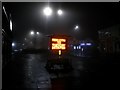
Wallisdown: advance warning of resurfacing works (2)
Can a warning be anything other than advance? Arriving on Wallisdown Roundabout from Kinson Road, motorists are warned that in a couple of weeks' time delays can be expected on Alder Road, the main road continuing straight on ahead.
The display flits between two messages every few seconds, this one giving the dates and the other giving the reason (Image).
Image: © Chris Downer
Taken: 31 Jan 2017
0.04 miles
6
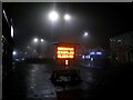
Wallisdown: advance warning of resurfacing works (1)
Can a warning be anything other than advance? Arriving on Wallisdown Roundabout from Kinson Road, motorists are warned that in a couple of weeks' time delays can be expected on Alder Road, the main road continuing straight on ahead.
The display flits between two messages every few seconds, this one giving the reason and the other giving the dates (Image).
Image: © Chris Downer
Taken: 31 Jan 2017
0.04 miles
7
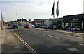
Wallisdown Road
Not quite the same view point as Image, but you can see that the BMW dealer has reopened.
Image: © David Lally
Taken: 18 Oct 2009
0.04 miles
8
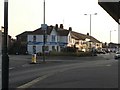
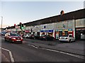
Wallisdown: Wallisdown Roundabout
This roundabout, roughly halfway along the busy A3049 Wallisdown Road, can be very congested at peak times, as it links with the A3040 Alder Road towards central Poole. Such is the layout of Bournemouth and Poole that, in this area, people are going to and from work in the same direction - indeed, all directions.
It is also on the boundary of the two boroughs: see Image (the same shops are visible in this and the linked image).
Image: © Chris Downer
Taken: 8 Jun 2008
0.05 miles
9
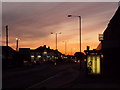
Wallisdown: the roundabout at sunset
Another view of Image, from a more distant position but similar direction. A sunny evening is drawing to a close.
Image: © Chris Downer
Taken: 1 Sep 2010
0.06 miles
10
Wallisdown: footpath U17 from Canford Road
Looking across the carriageway of Canford Road as a public footpath heads westward from it. The little road alongside is an offshoot of Canford Road and the public footpath was almost certainly established before the road was built - the path today basically forms the pavement alongside the road, for this eastern part.
See Image for the next view along the footpath.
Image: © Chris Downer
Taken: 12 Jul 2016
0.08 miles