IMAGES TAKEN NEAR TO
Holworth Close, BOURNEMOUTH, BH11 8PF
Introduction
This page details the photographs taken nearby to Holworth Close, BH11 8PF by members of the Geograph project.
The Geograph project started in 2005 with the aim of publishing, organising and preserving representative images for every square kilometre of Great Britain, Ireland and the Isle of Man.

There are currently over 7.5m images from over14,400 individuals and you can help contribute to the project by visiting https://www.geograph.org.uk
Image Map (49 Images)


Getting Data...Please wait
Leaflet Map data © OpenStreetMap
Images are licensed for reuse under creativecommons.org/licenses/by-sa/2.0
Notes
- Clicking on the map will re-center to the selected point.
- The higher the marker number, the further away the image location is from the centre of the postcode.
Image Listing (49 Images Found)
Images are licensed for reuse under creativecommons.org/licenses/by-sa/2.0
Image
Details
Distance
1
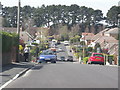
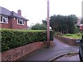
West Howe: postbox № BH11 301, Littlemoor Avenue
Looking along Littlemoor Avenue, which turns right in the distance and follows the borough boundary so that the houses on the back are actually in Poole whereas the rest are in Bournemouth.
Image: © Chris Downer
Taken: 4 Jan 2009
0.03 miles
2
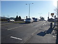
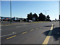
Bournemouth : Ringwood Road A348
Ringwood Road and another pesky speed camera in view.
Image: © Lewis Clarke
Taken: 8 Mar 2010
0.06 miles
3
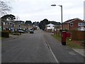
Bournemouth : Littlemore Avenue
A residential road taken from the junction of Ringwood Road.
Image: © Lewis Clarke
Taken: 8 Mar 2010
0.07 miles
4
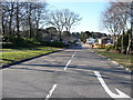
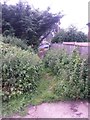
West Howe: footpath U11 to High Howe Close
A very short public footpath, at 13 metres in length, leading to the dead end of one of the offshoots of High Howe Close. This end is a gravel rear-access driveway for Ringwood Road properties.
The extent of the right of way appears to be just the tarmacked part, and not the rough path which leads to it: see Image for a picture from the opposite end.
See Image for a wider view of this approach to the path.
Image: © Chris Downer
Taken: 26 Jun 2016
0.09 miles
5
Bournemouth : Ringwood Road A348
Ringwood Road taken from one of the bus stops - there aren't any buses in it.
Image: © Lewis Clarke
Taken: 8 Mar 2010
0.09 miles
6
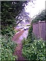
West Howe: approaching footpath U11
A wider view of Image, showing the approach to the footpath from this gravel rear-access driveway for some Ringwood Road properties.
A very short public footpath, at 13 metres in length, it leads to the dead end of one of the offshoots of High Howe Close.
Image: © Chris Downer
Taken: 26 Jun 2016
0.10 miles
7
West Howe: footpath U11 from High Howe Close
A very short public footpath, at 13 metres in length, leading from a dead end of one of the offshoots of High Howe Close. It comes out on a gravel rear-access driveway for Ringwood Road properties.
The extent of the right of way appears to be just the tarmacked part, and not the rough path which follows: see Image for a picture from the opposite end.
The route does not save much time for the pedestrian, compared with walking around by road, because all you can do at the end is turn right parallel with the road a few yards behind us.
Image: © Chris Downer
Taken: 26 Jun 2016
0.10 miles
8
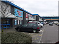
West Howe Retail Park
Although marked as an industrial estate on the mapsjust next to the A348 in Bournemouth, the buildings are all retailers such as Argos
Image: © Nigel Mykura
Taken: 16 Mar 2008
0.12 miles
9
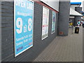
Argos at West Howe Retail Park
Argos is one of the main shops at this urban shopping centre just north of Bournemouth town centre
Image: © Nigel Mykura
Taken: 16 Mar 2008
0.12 miles